You are here: Home > Network List > TX - Texas Seismological Network Stations List
> Station MB04 Seminole > Earthquake Result Viewer
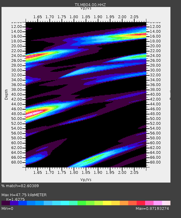
MB04 Seminole - Earthquake Result Viewer
| Earthquake location: |
South Of Alaska |
| Earthquake latitude/longitude: |
54.3/-159.7 |
| Earthquake time(UTC): |
2020/10/20 (294) 04:07:06 GMT |
| Earthquake Depth: |
6.1 km |
| Earthquake Magnitude: |
5.6 mww |
| Earthquake Catalog/Contributor: |
NEIC PDE/us |
|
| Network: |
TX Texas Seismological Network |
| Station: |
MB04 Seminole |
| Lat/Lon: |
32.63 N/102.49 W |
| Elevation: |
956 m |
|
| Distance: |
45.4 deg |
| Az: |
94.517 deg |
| Baz: |
316.186 deg |
| Ray Param: |
0.07135211 |
| Estimated Moho Depth: |
47.75 km |
| Estimated Crust Vp/Vs: |
1.63 |
| Assumed Crust Vp: |
6.129 km/s |
| Estimated Crust Vs: |
3.766 km/s |
| Estimated Crust Poisson's Ratio: |
0.20 |
|
| Radial Match: |
82.60389 % |
| Radial Bump: |
366 |
| Transverse Match: |
54.744133 % |
| Transverse Bump: |
400 |
| SOD ConfigId: |
22732711 |
| Insert Time: |
2020-11-03 04:29:02.595 +0000 |
| GWidth: |
2.5 |
| Max Bumps: |
400 |
| Tol: |
0.001 |
|

Signal To Noise
| Channel | StoN | STA | LTA |
| TX:MB04:00:HHZ:20201020T04:14:54.129995Z | 11.019967 | 5.423516E-7 | 4.9215355E-8 |
| TX:MB04:00:HH1:20201020T04:14:54.129995Z | 2.759524 | 3.0907782E-7 | 1.1200403E-7 |
| TX:MB04:00:HH2:20201020T04:14:54.129995Z | 1.7802495 | 1.9102407E-7 | 1.0730186E-7 |
| Arrivals |
| Ps | 5.2 SECOND |
| PpPs | 19 SECOND |
| PsPs/PpSs | 24 SECOND |


