You are here: Home > Network List > TX - Texas Seismological Network Stations List
> Station WTFS Witchita Falls > Earthquake Result Viewer
WTFS Witchita Falls - Earthquake Result Viewer
*The percent match for this event was below the threshold and hence no stack was calculated.
| Earthquake location: |
South Of Alaska |
| Earthquake latitude/longitude: |
54.3/-159.7 |
| Earthquake time(UTC): |
2020/10/20 (294) 04:07:06 GMT |
| Earthquake Depth: |
6.1 km |
| Earthquake Magnitude: |
5.6 mww |
| Earthquake Catalog/Contributor: |
NEIC PDE/us |
|
| Network: |
TX Texas Seismological Network |
| Station: |
WTFS Witchita Falls |
| Lat/Lon: |
33.77 N/98.46 W |
| Elevation: |
277 m |
|
| Distance: |
46.9 deg |
| Az: |
90.064 deg |
| Baz: |
315.292 deg |
| Ray Param: |
$rayparam |
*The percent match for this event was below the threshold and hence was not used in the summary stack. |
|
| Radial Match: |
73.054245 % |
| Radial Bump: |
382 |
| Transverse Match: |
64.01045 % |
| Transverse Bump: |
396 |
| SOD ConfigId: |
22732711 |
| Insert Time: |
2020-11-03 04:29:46.056 +0000 |
| GWidth: |
2.5 |
| Max Bumps: |
400 |
| Tol: |
0.001 |
|
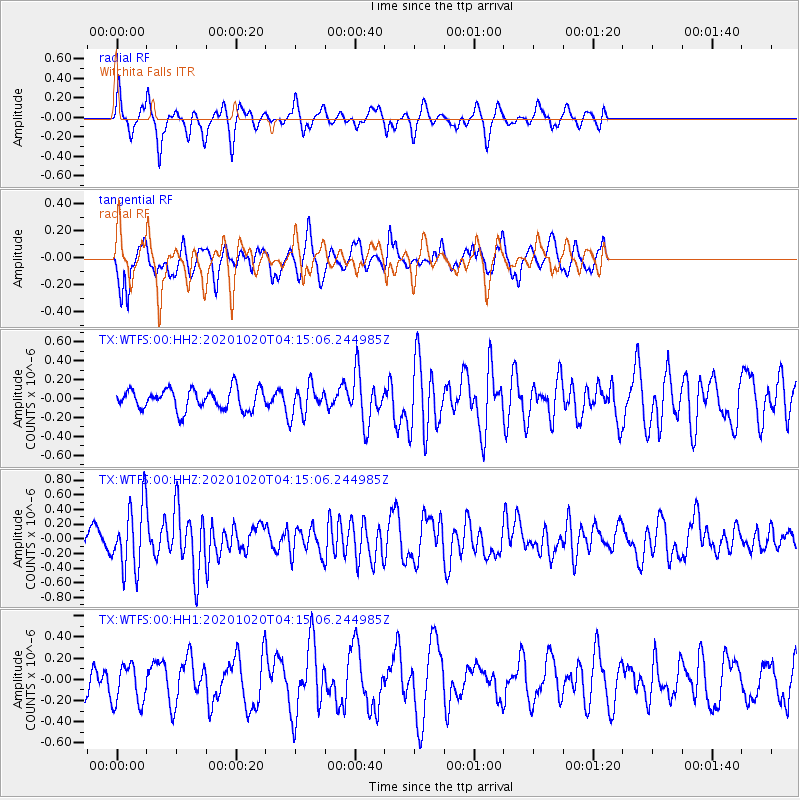
Signal To Noise
| Channel | StoN | STA | LTA |
| TX:WTFS:00:HHZ:20201020T04:15:06.244985Z | 3.468701 | 4.420869E-7 | 1.2745028E-7 |
| TX:WTFS:00:HH1:20201020T04:15:06.244985Z | 1.3297217 | 1.8952986E-7 | 1.4253348E-7 |
| TX:WTFS:00:HH2:20201020T04:15:06.244985Z | 1.4424322 | 1.580422E-7 | 1.0956647E-7 |
| Arrivals |
| Ps | |
| PpPs | |
| PsPs/PpSs | |


