You are here: Home > Network List > US - United States National Seismic Network Stations List
> Station EGMT Eagleton, Montana, USA > Earthquake Result Viewer
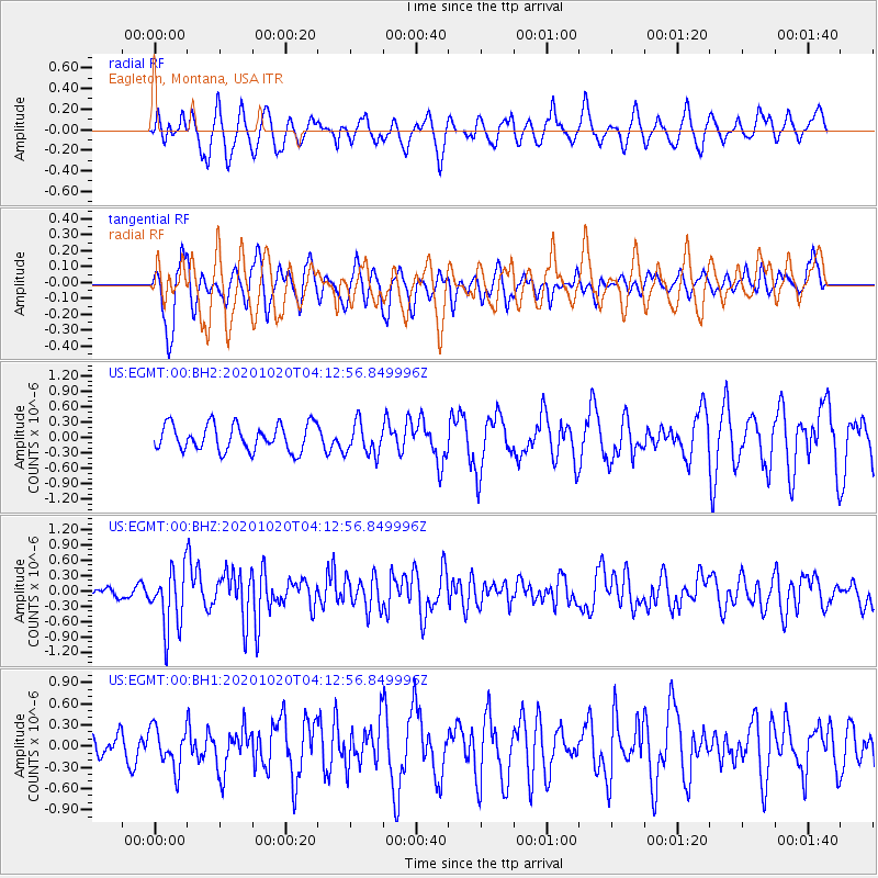
EGMT Eagleton, Montana, USA - Earthquake Result Viewer
*The percent match for this event was below the threshold and hence no stack was calculated.
| Earthquake location: |
South Of Alaska |
| Earthquake latitude/longitude: |
54.3/-159.7 |
| Earthquake time(UTC): |
2020/10/20 (294) 04:07:06 GMT |
| Earthquake Depth: |
6.1 km |
| Earthquake Magnitude: |
5.6 mww |
| Earthquake Catalog/Contributor: |
NEIC PDE/us |
|
| Network: |
US United States National Seismic Network |
| Station: |
EGMT Eagleton, Montana, USA |
| Lat/Lon: |
48.02 N/109.75 W |
| Elevation: |
1055 m |
|
| Distance: |
31.4 deg |
| Az: |
80.694 deg |
| Baz: |
300.516 deg |
| Ray Param: |
$rayparam |
*The percent match for this event was below the threshold and hence was not used in the summary stack. |
|
| Radial Match: |
45.810825 % |
| Radial Bump: |
400 |
| Transverse Match: |
70.27042 % |
| Transverse Bump: |
400 |
| SOD ConfigId: |
22732711 |
| Insert Time: |
2020-11-03 04:30:09.263 +0000 |
| GWidth: |
2.5 |
| Max Bumps: |
400 |
| Tol: |
0.001 |
|
Signal To Noise
| Channel | StoN | STA | LTA |
| US:EGMT:00:BHZ:20201020T04:12:56.849996Z | 3.3402934 | 5.8947296E-7 | 1.764734E-7 |
| US:EGMT:00:BH1:20201020T04:12:56.849996Z | 1.4979602 | 2.8397454E-7 | 1.8957415E-7 |
| US:EGMT:00:BH2:20201020T04:12:56.849996Z | 1.2144378 | 3.116167E-7 | 2.5659335E-7 |
| Arrivals |
| Ps | |
| PpPs | |
| PsPs/PpSs | |


