You are here: Home > Network List > TA - USArray Transportable Network (new EarthScope stations) Stations List
> Station I17K Unalakleet, AK, USA > Earthquake Result Viewer
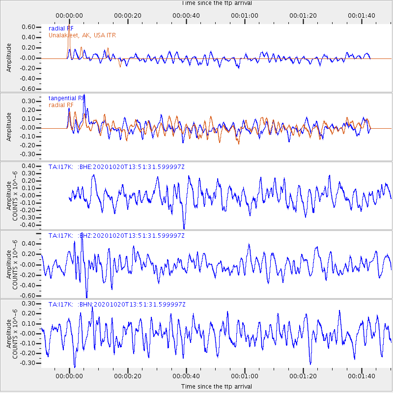
I17K Unalakleet, AK, USA - Earthquake Result Viewer
*The percent match for this event was below the threshold and hence no stack was calculated.
| Earthquake location: |
Iceland |
| Earthquake latitude/longitude: |
64.0/-22.1 |
| Earthquake time(UTC): |
2020/10/20 (294) 13:43:17 GMT |
| Earthquake Depth: |
10 km |
| Earthquake Magnitude: |
5.6 mww |
| Earthquake Catalog/Contributor: |
NEIC PDE/us |
|
| Network: |
TA USArray Transportable Network (new EarthScope stations) |
| Station: |
I17K Unalakleet, AK, USA |
| Lat/Lon: |
63.89 N/160.70 W |
| Elevation: |
105 m |
|
| Distance: |
48.8 deg |
| Az: |
337.079 deg |
| Baz: |
22.813 deg |
| Ray Param: |
$rayparam |
*The percent match for this event was below the threshold and hence was not used in the summary stack. |
|
| Radial Match: |
42.2459 % |
| Radial Bump: |
400 |
| Transverse Match: |
56.44916 % |
| Transverse Bump: |
400 |
| SOD ConfigId: |
22732711 |
| Insert Time: |
2020-11-03 14:01:56.809 +0000 |
| GWidth: |
2.5 |
| Max Bumps: |
400 |
| Tol: |
0.001 |
|
Signal To Noise
| Channel | StoN | STA | LTA |
| TA:I17K: :BHZ:20201020T13:51:31.599997Z | 2.3161852 | 2.6397498E-7 | 1.13969726E-7 |
| TA:I17K: :BHN:20201020T13:51:31.599997Z | 1.5080117 | 1.5709847E-7 | 1.041759E-7 |
| TA:I17K: :BHE:20201020T13:51:31.599997Z | 1.2593814 | 1.282686E-7 | 1.0185047E-7 |
| Arrivals |
| Ps | |
| PpPs | |
| PsPs/PpSs | |


