You are here: Home > Network List > TA - USArray Transportable Network (new EarthScope stations) Stations List
> Station R33M Jennings River, BC, CAN > Earthquake Result Viewer
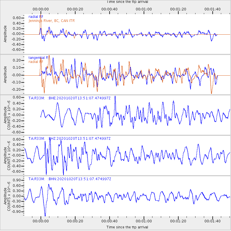
R33M Jennings River, BC, CAN - Earthquake Result Viewer
*The percent match for this event was below the threshold and hence no stack was calculated.
| Earthquake location: |
Iceland |
| Earthquake latitude/longitude: |
64.0/-22.1 |
| Earthquake time(UTC): |
2020/10/20 (294) 13:43:17 GMT |
| Earthquake Depth: |
10 km |
| Earthquake Magnitude: |
5.6 mww |
| Earthquake Catalog/Contributor: |
NEIC PDE/us |
|
| Network: |
TA USArray Transportable Network (new EarthScope stations) |
| Station: |
R33M Jennings River, BC, CAN |
| Lat/Lon: |
59.39 N/130.97 W |
| Elevation: |
1437 m |
|
| Distance: |
45.7 deg |
| Az: |
317.402 deg |
| Baz: |
35.649 deg |
| Ray Param: |
$rayparam |
*The percent match for this event was below the threshold and hence was not used in the summary stack. |
|
| Radial Match: |
65.96635 % |
| Radial Bump: |
398 |
| Transverse Match: |
26.728657 % |
| Transverse Bump: |
325 |
| SOD ConfigId: |
22732711 |
| Insert Time: |
2020-11-03 14:02:25.828 +0000 |
| GWidth: |
2.5 |
| Max Bumps: |
400 |
| Tol: |
0.001 |
|
Signal To Noise
| Channel | StoN | STA | LTA |
| TA:R33M: :BHZ:20201020T13:51:07.474997Z | 1.7222276 | 2.410358E-7 | 1.3995583E-7 |
| TA:R33M: :BHN:20201020T13:51:07.474997Z | 3.426656 | 5.348987E-7 | 1.5609932E-7 |
| TA:R33M: :BHE:20201020T13:51:07.474997Z | 0.8510997 | 1.5690068E-7 | 1.8435053E-7 |
| Arrivals |
| Ps | |
| PpPs | |
| PsPs/PpSs | |


