You are here: Home > Network List > US - United States National Seismic Network Stations List
> Station WMOK Wichita Mountains, Oklahoma, USA > Earthquake Result Viewer
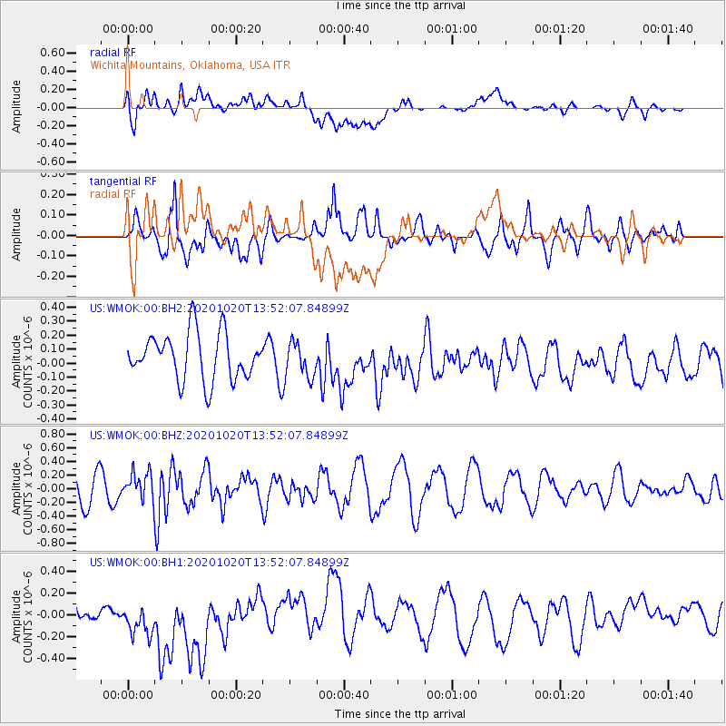
WMOK Wichita Mountains, Oklahoma, USA - Earthquake Result Viewer
*The percent match for this event was below the threshold and hence no stack was calculated.
| Earthquake location: |
Iceland |
| Earthquake latitude/longitude: |
64.0/-22.1 |
| Earthquake time(UTC): |
2020/10/20 (294) 13:43:17 GMT |
| Earthquake Depth: |
10 km |
| Earthquake Magnitude: |
5.6 mww |
| Earthquake Catalog/Contributor: |
NEIC PDE/us |
|
| Network: |
US United States National Seismic Network |
| Station: |
WMOK Wichita Mountains, Oklahoma, USA |
| Lat/Lon: |
34.74 N/98.78 W |
| Elevation: |
486 m |
|
| Distance: |
53.6 deg |
| Az: |
275.63 deg |
| Baz: |
32.167 deg |
| Ray Param: |
$rayparam |
*The percent match for this event was below the threshold and hence was not used in the summary stack. |
|
| Radial Match: |
43.708187 % |
| Radial Bump: |
400 |
| Transverse Match: |
59.25082 % |
| Transverse Bump: |
400 |
| SOD ConfigId: |
22732711 |
| Insert Time: |
2020-11-03 14:04:32.674 +0000 |
| GWidth: |
2.5 |
| Max Bumps: |
400 |
| Tol: |
0.001 |
|
Signal To Noise
| Channel | StoN | STA | LTA |
| US:WMOK:00:BHZ:20201020T13:52:07.84899Z | 1.1367441 | 2.0179561E-7 | 1.775207E-7 |
| US:WMOK:00:BH1:20201020T13:52:07.84899Z | 1.740805 | 2.8648785E-7 | 1.6457204E-7 |
| US:WMOK:00:BH2:20201020T13:52:07.84899Z | 0.7476549 | 1.252272E-7 | 1.6749333E-7 |
| Arrivals |
| Ps | |
| PpPs | |
| PsPs/PpSs | |


