You are here: Home > Network List > US - United States National Seismic Network Stations List
> Station MNTX Cornudas Mountains, Texas, USA > Earthquake Result Viewer
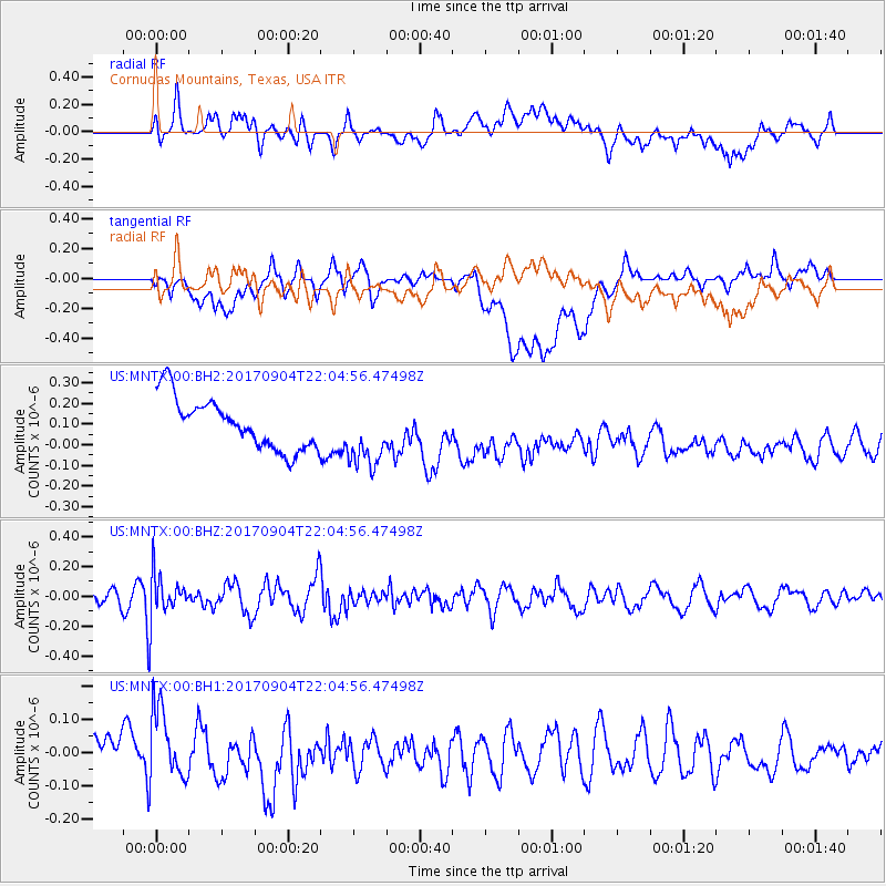
MNTX Cornudas Mountains, Texas, USA - Earthquake Result Viewer
*The percent match for this event was below the threshold and hence no stack was calculated.
| Earthquake location: |
Near Coast Of Northern Chile |
| Earthquake latitude/longitude: |
-19.3/-70.0 |
| Earthquake time(UTC): |
2017/09/04 (247) 21:55:20 GMT |
| Earthquake Depth: |
63 km |
| Earthquake Magnitude: |
5.1 Mwr |
| Earthquake Catalog/Contributor: |
NEIC PDE/us |
|
| Network: |
US United States National Seismic Network |
| Station: |
MNTX Cornudas Mountains, Texas, USA |
| Lat/Lon: |
31.70 N/105.38 W |
| Elevation: |
404 m |
|
| Distance: |
61.0 deg |
| Az: |
325.675 deg |
| Baz: |
141.332 deg |
| Ray Param: |
$rayparam |
*The percent match for this event was below the threshold and hence was not used in the summary stack. |
|
| Radial Match: |
48.80681 % |
| Radial Bump: |
400 |
| Transverse Match: |
39.62106 % |
| Transverse Bump: |
400 |
| SOD ConfigId: |
2307692 |
| Insert Time: |
2017-09-18 21:59:51.905 +0000 |
| GWidth: |
2.5 |
| Max Bumps: |
400 |
| Tol: |
0.001 |
|
Signal To Noise
| Channel | StoN | STA | LTA |
| US:MNTX:00:BHZ:20170904T22:04:56.47498Z | 2.0071473 | 1.4331728E-7 | 7.140346E-8 |
| US:MNTX:00:BH1:20170904T22:04:56.47498Z | 2.4053216 | 1.0500576E-7 | 4.36556E-8 |
| US:MNTX:00:BH2:20170904T22:04:56.47498Z | 1.3292758 | 1.6293981E-7 | 1.2257787E-7 |
| Arrivals |
| Ps | |
| PpPs | |
| PsPs/PpSs | |


