You are here: Home > Network List > AV - Alaska Volcano Observatory Stations List
> Station SPCR Ckakachatna River, Mount Spurr, Alaska > Earthquake Result Viewer
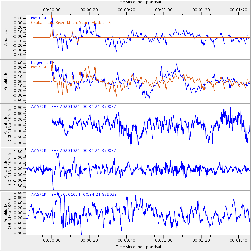
SPCR Ckakachatna River, Mount Spurr, Alaska - Earthquake Result Viewer
*The percent match for this event was below the threshold and hence no stack was calculated.
| Earthquake location: |
Tonga Islands Region |
| Earthquake latitude/longitude: |
-19.3/-172.4 |
| Earthquake time(UTC): |
2020/10/21 (295) 00:22:33 GMT |
| Earthquake Depth: |
10 km |
| Earthquake Magnitude: |
5.9 mww |
| Earthquake Catalog/Contributor: |
NEIC PDE/us |
|
| Network: |
AV Alaska Volcano Observatory |
| Station: |
SPCR Ckakachatna River, Mount Spurr, Alaska |
| Lat/Lon: |
61.20 N/152.21 W |
| Elevation: |
984 m |
|
| Distance: |
81.9 deg |
| Az: |
9.715 deg |
| Baz: |
199.213 deg |
| Ray Param: |
$rayparam |
*The percent match for this event was below the threshold and hence was not used in the summary stack. |
|
| Radial Match: |
53.767574 % |
| Radial Bump: |
400 |
| Transverse Match: |
58.16936 % |
| Transverse Bump: |
400 |
| SOD ConfigId: |
22732711 |
| Insert Time: |
2020-11-04 00:30:42.696 +0000 |
| GWidth: |
2.5 |
| Max Bumps: |
400 |
| Tol: |
0.001 |
|
Signal To Noise
| Channel | StoN | STA | LTA |
| AV:SPCR: :BHZ:20201021T00:34:21.85903Z | 6.8001585 | 8.9084864E-7 | 1.310041E-7 |
| AV:SPCR: :BHN:20201021T00:34:21.85903Z | 2.7310376 | 5.426526E-7 | 1.9869832E-7 |
| AV:SPCR: :BHE:20201021T00:34:21.85903Z | 1.0193619 | 2.2189602E-7 | 2.176813E-7 |
| Arrivals |
| Ps | |
| PpPs | |
| PsPs/PpSs | |


