You are here: Home > Network List > CI - Caltech Regional Seismic Network Stations List
> Station MLAC Mammoth Lakes, California, USA > Earthquake Result Viewer
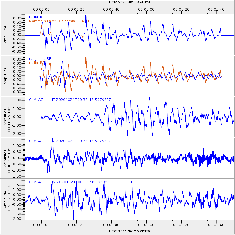
MLAC Mammoth Lakes, California, USA - Earthquake Result Viewer
*The percent match for this event was below the threshold and hence no stack was calculated.
| Earthquake location: |
Tonga Islands Region |
| Earthquake latitude/longitude: |
-19.3/-172.4 |
| Earthquake time(UTC): |
2020/10/21 (295) 00:22:33 GMT |
| Earthquake Depth: |
10 km |
| Earthquake Magnitude: |
5.9 mww |
| Earthquake Catalog/Contributor: |
NEIC PDE/us |
|
| Network: |
CI Caltech Regional Seismic Network |
| Station: |
MLAC Mammoth Lakes, California, USA |
| Lat/Lon: |
37.63 N/118.84 W |
| Elevation: |
2134 m |
|
| Distance: |
75.8 deg |
| Az: |
41.209 deg |
| Baz: |
231.595 deg |
| Ray Param: |
$rayparam |
*The percent match for this event was below the threshold and hence was not used in the summary stack. |
|
| Radial Match: |
78.14297 % |
| Radial Bump: |
400 |
| Transverse Match: |
78.04035 % |
| Transverse Bump: |
400 |
| SOD ConfigId: |
22732711 |
| Insert Time: |
2020-11-04 00:34:27.708 +0000 |
| GWidth: |
2.5 |
| Max Bumps: |
400 |
| Tol: |
0.001 |
|
Signal To Noise
| Channel | StoN | STA | LTA |
| CI:MLAC: :HHZ:20201021T00:33:48.597983Z | 3.9274945 | 4.1964847E-7 | 1.068489E-7 |
| CI:MLAC: :HHN:20201021T00:33:48.597983Z | 1.7779838 | 3.6034606E-7 | 2.0267117E-7 |
| CI:MLAC: :HHE:20201021T00:33:48.597983Z | 1.3654096 | 3.5925908E-7 | 2.631145E-7 |
| Arrivals |
| Ps | |
| PpPs | |
| PsPs/PpSs | |


