You are here: Home > Network List > CI - Caltech Regional Seismic Network Stations List
> Station MPP McPhearson Peak > Earthquake Result Viewer
MPP McPhearson Peak - Earthquake Result Viewer
*The percent match for this event was below the threshold and hence no stack was calculated.
| Earthquake location: |
Tonga Islands Region |
| Earthquake latitude/longitude: |
-19.3/-172.4 |
| Earthquake time(UTC): |
2020/10/21 (295) 00:22:33 GMT |
| Earthquake Depth: |
10 km |
| Earthquake Magnitude: |
5.9 mww |
| Earthquake Catalog/Contributor: |
NEIC PDE/us |
|
| Network: |
CI Caltech Regional Seismic Network |
| Station: |
MPP McPhearson Peak |
| Lat/Lon: |
34.89 N/119.81 W |
| Elevation: |
1739 m |
|
| Distance: |
73.5 deg |
| Az: |
42.921 deg |
| Baz: |
231.473 deg |
| Ray Param: |
$rayparam |
*The percent match for this event was below the threshold and hence was not used in the summary stack. |
|
| Radial Match: |
54.57657 % |
| Radial Bump: |
400 |
| Transverse Match: |
61.83016 % |
| Transverse Bump: |
400 |
| SOD ConfigId: |
22732711 |
| Insert Time: |
2020-11-04 00:34:29.602 +0000 |
| GWidth: |
2.5 |
| Max Bumps: |
400 |
| Tol: |
0.001 |
|
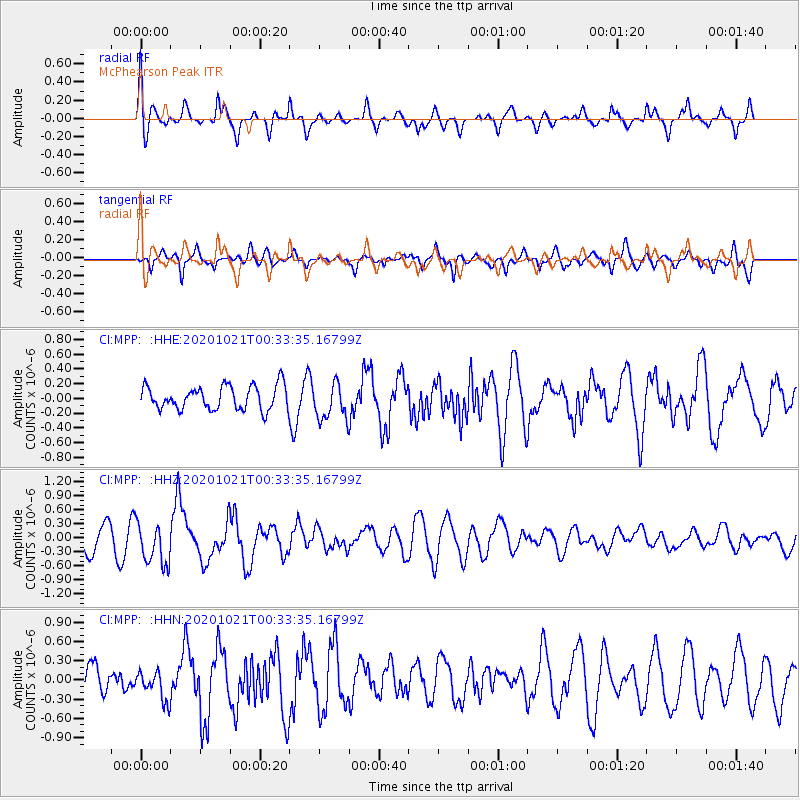
Signal To Noise
| Channel | StoN | STA | LTA |
| CI:MPP: :HHZ:20201021T00:33:35.16799Z | 1.6678928 | 4.5077044E-7 | 2.7026343E-7 |
| CI:MPP: :HHN:20201021T00:33:35.16799Z | 0.96862173 | 2.199776E-7 | 2.2710371E-7 |
| CI:MPP: :HHE:20201021T00:33:35.16799Z | 1.5597451 | 2.497325E-7 | 1.601111E-7 |
| Arrivals |
| Ps | |
| PpPs | |
| PsPs/PpSs | |


