You are here: Home > Network List > GS - US Geological Survey Networks Stations List
> Station ASA1 ASA1 > Earthquake Result Viewer
ASA1 ASA1 - Earthquake Result Viewer
| Earthquake location: |
Tonga Islands Region |
| Earthquake latitude/longitude: |
-19.3/-172.4 |
| Earthquake time(UTC): |
2020/10/21 (295) 00:22:33 GMT |
| Earthquake Depth: |
10 km |
| Earthquake Magnitude: |
5.9 mww |
| Earthquake Catalog/Contributor: |
NEIC PDE/us |
|
| Network: |
GS US Geological Survey Networks |
| Station: |
ASA1 ASA1 |
| Lat/Lon: |
34.95 N/106.46 W |
| Elevation: |
1829 m |
|
| Distance: |
82.6 deg |
| Az: |
49.144 deg |
| Baz: |
240.402 deg |
| Ray Param: |
0.046783514 |
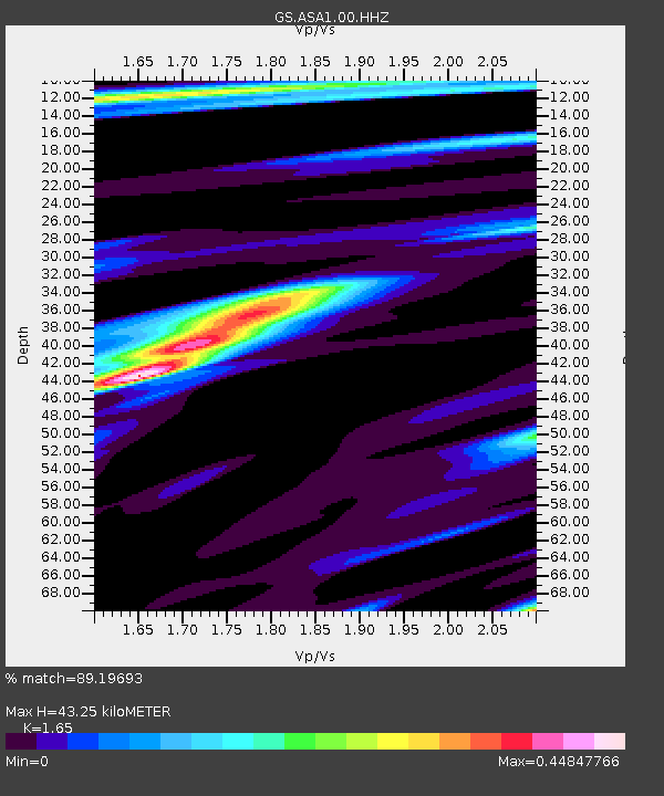
| Estimated Moho Depth: |
43.25 km |
| Estimated Crust Vp/Vs: |
1.65 |
| Assumed Crust Vp: |
6.502 km/s |
| Estimated Crust Vs: |
3.94 km/s |
| Estimated Crust Poisson's Ratio: |
0.21 |
|
| Radial Match: |
89.19693 % |
| Radial Bump: |
273 |
| Transverse Match: |
83.06597 % |
| Transverse Bump: |
348 |
| SOD ConfigId: |
22732711 |
| Insert Time: |
2020-11-04 00:37:23.305 +0000 |
| GWidth: |
2.5 |
| Max Bumps: |
400 |
| Tol: |
0.001 |
|

Signal To Noise
| Channel | StoN | STA | LTA |
| GS:ASA1:00:HHZ:20201021T00:34:25.659018Z | 8.546912 | 4.718319E-7 | 5.5204953E-8 |
| GS:ASA1:00:HH1:20201021T00:34:25.659018Z | 1.5015316 | 9.456678E-8 | 6.298021E-8 |
| GS:ASA1:00:HH2:20201021T00:34:25.659018Z | 1.8232787 | 1.3294087E-7 | 7.291308E-8 |
| Arrivals |
| Ps | 4.5 SECOND |
| PpPs | 17 SECOND |
| PsPs/PpSs | 22 SECOND |


