You are here: Home > Network List > GS - US Geological Survey Networks Stations List
> Station ASA4 ASA4 > Earthquake Result Viewer
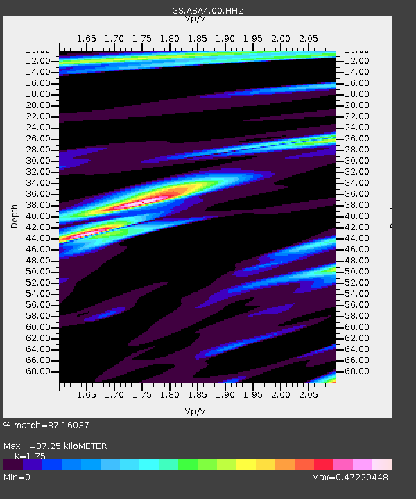
ASA4 ASA4 - Earthquake Result Viewer
| Earthquake location: |
Tonga Islands Region |
| Earthquake latitude/longitude: |
-19.3/-172.4 |
| Earthquake time(UTC): |
2020/10/21 (295) 00:22:33 GMT |
| Earthquake Depth: |
10 km |
| Earthquake Magnitude: |
5.9 mww |
| Earthquake Catalog/Contributor: |
NEIC PDE/us |
|
| Network: |
GS US Geological Survey Networks |
| Station: |
ASA4 ASA4 |
| Lat/Lon: |
34.94 N/106.46 W |
| Elevation: |
1820 m |
|
| Distance: |
82.6 deg |
| Az: |
49.147 deg |
| Baz: |
240.4 deg |
| Ray Param: |
0.04678603 |
| Estimated Moho Depth: |
37.25 km |
| Estimated Crust Vp/Vs: |
1.75 |
| Assumed Crust Vp: |
6.502 km/s |
| Estimated Crust Vs: |
3.715 km/s |
| Estimated Crust Poisson's Ratio: |
0.26 |
|
| Radial Match: |
87.16037 % |
| Radial Bump: |
228 |
| Transverse Match: |
72.59444 % |
| Transverse Bump: |
287 |
| SOD ConfigId: |
22732711 |
| Insert Time: |
2020-11-04 00:37:27.235 +0000 |
| GWidth: |
2.5 |
| Max Bumps: |
400 |
| Tol: |
0.001 |
|

Signal To Noise
| Channel | StoN | STA | LTA |
| GS:ASA4:00:HHZ:20201021T00:34:25.639975Z | 8.198523 | 4.7053203E-7 | 5.73923E-8 |
| GS:ASA4:00:HH1:20201021T00:34:25.639975Z | 1.4732758 | 9.670226E-8 | 6.563758E-8 |
| GS:ASA4:00:HH2:20201021T00:34:25.639975Z | 1.9178852 | 1.3605784E-7 | 7.0941596E-8 |
| Arrivals |
| Ps | 4.4 SECOND |
| PpPs | 15 SECOND |
| PsPs/PpSs | 20 SECOND |


