You are here: Home > Network List > GS - US Geological Survey Networks Stations List
> Station ASA5 ASA5 > Earthquake Result Viewer
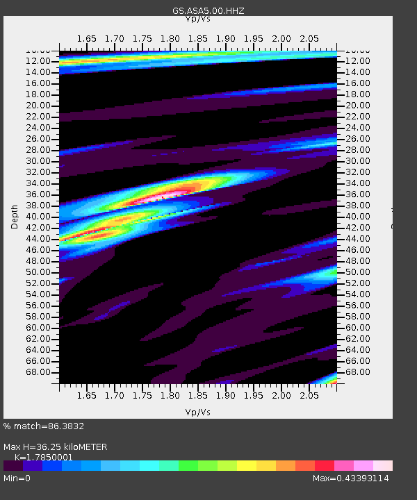
ASA5 ASA5 - Earthquake Result Viewer
| Earthquake location: |
Tonga Islands Region |
| Earthquake latitude/longitude: |
-19.3/-172.4 |
| Earthquake time(UTC): |
2020/10/21 (295) 00:22:33 GMT |
| Earthquake Depth: |
10 km |
| Earthquake Magnitude: |
5.9 mww |
| Earthquake Catalog/Contributor: |
NEIC PDE/us |
|
| Network: |
GS US Geological Survey Networks |
| Station: |
ASA5 ASA5 |
| Lat/Lon: |
34.94 N/106.46 W |
| Elevation: |
1835 m |
|
| Distance: |
82.6 deg |
| Az: |
49.147 deg |
| Baz: |
240.402 deg |
| Ray Param: |
0.046784338 |
| Estimated Moho Depth: |
36.25 km |
| Estimated Crust Vp/Vs: |
1.79 |
| Assumed Crust Vp: |
6.502 km/s |
| Estimated Crust Vs: |
3.642 km/s |
| Estimated Crust Poisson's Ratio: |
0.27 |
|
| Radial Match: |
86.3832 % |
| Radial Bump: |
245 |
| Transverse Match: |
73.09596 % |
| Transverse Bump: |
281 |
| SOD ConfigId: |
22732711 |
| Insert Time: |
2020-11-04 00:37:27.675 +0000 |
| GWidth: |
2.5 |
| Max Bumps: |
400 |
| Tol: |
0.001 |
|

Signal To Noise
| Channel | StoN | STA | LTA |
| GS:ASA5:00:HHZ:20201021T00:34:25.649985Z | 8.450262 | 4.7385672E-7 | 5.607598E-8 |
| GS:ASA5:00:HH1:20201021T00:34:25.649985Z | 1.4135432 | 9.07221E-8 | 6.418063E-8 |
| GS:ASA5:00:HH2:20201021T00:34:25.649985Z | 1.8900858 | 1.3162399E-7 | 6.9639164E-8 |
| Arrivals |
| Ps | 4.5 SECOND |
| PpPs | 15 SECOND |
| PsPs/PpSs | 20 SECOND |


