You are here: Home > Network List > GS - US Geological Survey Networks Stations List
> Station OK051 E0350 and S34600 Roads, Ralston, OK > Earthquake Result Viewer
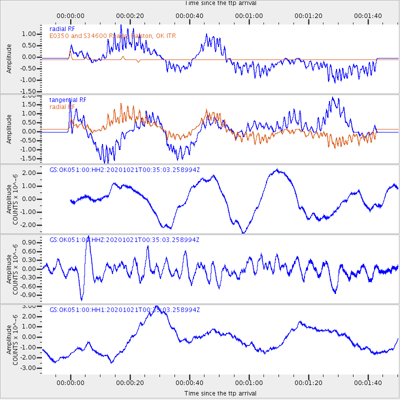
OK051 E0350 and S34600 Roads, Ralston, OK - Earthquake Result Viewer
*The percent match for this event was below the threshold and hence no stack was calculated.
| Earthquake location: |
Tonga Islands Region |
| Earthquake latitude/longitude: |
-19.3/-172.4 |
| Earthquake time(UTC): |
2020/10/21 (295) 00:22:33 GMT |
| Earthquake Depth: |
10 km |
| Earthquake Magnitude: |
5.9 mww |
| Earthquake Catalog/Contributor: |
NEIC PDE/us |
|
| Network: |
GS US Geological Survey Networks |
| Station: |
OK051 E0350 and S34600 Roads, Ralston, OK |
| Lat/Lon: |
36.51 N/96.84 W |
| Elevation: |
263 m |
|
| Distance: |
90.3 deg |
| Az: |
51.282 deg |
| Baz: |
246.139 deg |
| Ray Param: |
$rayparam |
*The percent match for this event was below the threshold and hence was not used in the summary stack. |
|
| Radial Match: |
67.07881 % |
| Radial Bump: |
333 |
| Transverse Match: |
59.406284 % |
| Transverse Bump: |
354 |
| SOD ConfigId: |
22732711 |
| Insert Time: |
2020-11-04 00:37:42.424 +0000 |
| GWidth: |
2.5 |
| Max Bumps: |
400 |
| Tol: |
0.001 |
|
Signal To Noise
| Channel | StoN | STA | LTA |
| GS:OK051:00:HHZ:20201021T00:35:03.258994Z | 2.7490308 | 4.2701842E-7 | 1.5533418E-7 |
| GS:OK051:00:HH1:20201021T00:35:03.258994Z | 1.2397277 | 3.1327893E-6 | 2.5269978E-6 |
| GS:OK051:00:HH2:20201021T00:35:03.258994Z | 5.265854 | 2.3538107E-6 | 4.4699505E-7 |
| Arrivals |
| Ps | |
| PpPs | |
| PsPs/PpSs | |


