You are here: Home > Network List > GS - US Geological Survey Networks Stations List
> Station VEA2 VEA1 > Earthquake Result Viewer
VEA2 VEA1 - Earthquake Result Viewer
| Earthquake location: |
Tonga Islands Region |
| Earthquake latitude/longitude: |
-19.3/-172.4 |
| Earthquake time(UTC): |
2020/10/21 (295) 00:22:33 GMT |
| Earthquake Depth: |
10 km |
| Earthquake Magnitude: |
5.9 mww |
| Earthquake Catalog/Contributor: |
NEIC PDE/us |
|
| Network: |
GS US Geological Survey Networks |
| Station: |
VEA2 VEA1 |
| Lat/Lon: |
34.94 N/106.46 W |
| Elevation: |
1844 m |
|
| Distance: |
82.6 deg |
| Az: |
49.146 deg |
| Baz: |
240.402 deg |
| Ray Param: |
0.046784047 |
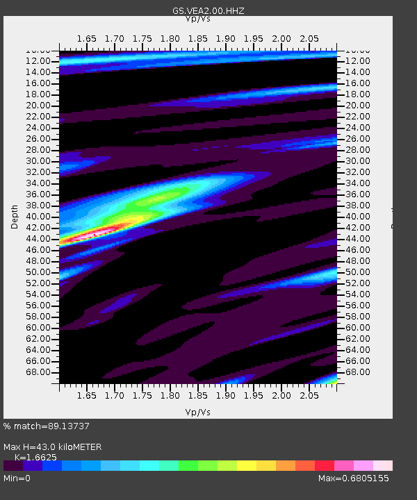
| Estimated Moho Depth: |
43.0 km |
| Estimated Crust Vp/Vs: |
1.66 |
| Assumed Crust Vp: |
6.502 km/s |
| Estimated Crust Vs: |
3.911 km/s |
| Estimated Crust Poisson's Ratio: |
0.22 |
|
| Radial Match: |
89.13737 % |
| Radial Bump: |
296 |
| Transverse Match: |
82.91633 % |
| Transverse Bump: |
299 |
| SOD ConfigId: |
22732711 |
| Insert Time: |
2020-11-04 00:37:45.358 +0000 |
| GWidth: |
2.5 |
| Max Bumps: |
400 |
| Tol: |
0.001 |
|

Signal To Noise
| Channel | StoN | STA | LTA |
| GS:VEA2:00:HHZ:20201021T00:34:25.649008Z | 8.326592 | 4.3528536E-7 | 5.227653E-8 |
| GS:VEA2:00:HH1:20201021T00:34:25.649008Z | 1.2591288 | 7.907568E-8 | 6.28019E-8 |
| GS:VEA2:00:HH2:20201021T00:34:25.649008Z | 2.0761015 | 1.294516E-7 | 6.235321E-8 |
| Arrivals |
| Ps | 4.5 SECOND |
| PpPs | 17 SECOND |
| PsPs/PpSs | 22 SECOND |


