You are here: Home > Network List > N4 - Central and EAstern US Network Stations List
> Station WHTX Lake Whitney, Meridian, TX, USA > Earthquake Result Viewer
WHTX Lake Whitney, Meridian, TX, USA - Earthquake Result Viewer
| Earthquake location: |
Tonga Islands Region |
| Earthquake latitude/longitude: |
-19.3/-172.4 |
| Earthquake time(UTC): |
2020/10/21 (295) 00:22:33 GMT |
| Earthquake Depth: |
10 km |
| Earthquake Magnitude: |
5.9 mww |
| Earthquake Catalog/Contributor: |
NEIC PDE/us |
|
| Network: |
N4 Central and EAstern US Network |
| Station: |
WHTX Lake Whitney, Meridian, TX, USA |
| Lat/Lon: |
31.99 N/97.46 W |
| Elevation: |
190 m |
|
| Distance: |
88.0 deg |
| Az: |
55.187 deg |
| Baz: |
245.85 deg |
| Ray Param: |
0.042928856 |
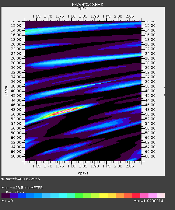
| Estimated Moho Depth: |
48.5 km |
| Estimated Crust Vp/Vs: |
1.77 |
| Assumed Crust Vp: |
6.347 km/s |
| Estimated Crust Vs: |
3.591 km/s |
| Estimated Crust Poisson's Ratio: |
0.26 |
|
| Radial Match: |
80.622955 % |
| Radial Bump: |
393 |
| Transverse Match: |
71.488884 % |
| Transverse Bump: |
400 |
| SOD ConfigId: |
22732711 |
| Insert Time: |
2020-11-04 00:40:08.163 +0000 |
| GWidth: |
2.5 |
| Max Bumps: |
400 |
| Tol: |
0.001 |
|

Signal To Noise
| Channel | StoN | STA | LTA |
| N4:WHTX:00:HHZ:20201021T00:34:52.488974Z | 4.8689976 | 5.111278E-7 | 1.04975975E-7 |
| N4:WHTX:00:HH1:20201021T00:34:52.488974Z | 1.4586086 | 1.5453605E-7 | 1.0594758E-7 |
| N4:WHTX:00:HH2:20201021T00:34:52.488974Z | 1.710893 | 1.5847789E-7 | 9.262875E-8 |
| Arrivals |
| Ps | 6.0 SECOND |
| PpPs | 21 SECOND |
| PsPs/PpSs | 27 SECOND |


