You are here: Home > Network List > LD - Lamont-Doherty Cooperative Seismographic Network Stations List
> Station FOR Fordham, University, the Bronx, NY > Earthquake Result Viewer
FOR Fordham, University, the Bronx, NY - Earthquake Result Viewer
| Earthquake location: |
Northwest Of Kuril Islands |
| Earthquake latitude/longitude: |
47.8/146.2 |
| Earthquake time(UTC): |
2002/11/17 (321) 04:53:53 GMT |
| Earthquake Depth: |
459 km |
| Earthquake Magnitude: |
7.3 MW, 7.3 MW |
| Earthquake Catalog/Contributor: |
WHDF/NEIC |
|
| Network: |
LD Lamont-Doherty Cooperative Seismographic Network |
| Station: |
FOR Fordham, University, the Bronx, NY |
| Lat/Lon: |
41.01 N/73.91 W |
| Elevation: |
24 m |
|
| Distance: |
84.7 deg |
| Az: |
29.326 deg |
| Baz: |
334.145 deg |
| Ray Param: |
0.04405892 |
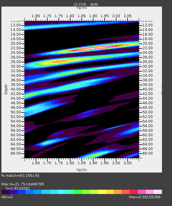
| Estimated Moho Depth: |
21.75 km |
| Estimated Crust Vp/Vs: |
1.91 |
| Assumed Crust Vp: |
6.472 km/s |
| Estimated Crust Vs: |
3.388 km/s |
| Estimated Crust Poisson's Ratio: |
0.31 |
|
| Radial Match: |
93.195145 % |
| Radial Bump: |
293 |
| Transverse Match: |
77.46634 % |
| Transverse Bump: |
400 |
| SOD ConfigId: |
4714 |
| Insert Time: |
2010-03-09 02:20:09.878 +0000 |
| GWidth: |
2.5 |
| Max Bumps: |
400 |
| Tol: |
0.001 |
|

Signal To Noise
| Channel | StoN | STA | LTA |
| LD:FOR: :BHN:20021117T05:05:07.274009Z | 7.385649 | 5.4610773E-6 | 7.394174E-7 |
| LD:FOR: :BHE:20021117T05:05:07.274009Z | 4.165127 | 3.310184E-6 | 7.9473784E-7 |
| LD:FOR: :BHZ:20021117T05:05:07.274009Z | 16.366627 | 1.6765793E-5 | 1.0243891E-6 |
| Arrivals |
| Ps | 3.1 SECOND |
| PpPs | 9.6 SECOND |
| PsPs/PpSs | 13 SECOND |


