You are here: Home > Network List > TX - Texas Seismological Network Stations List
> Station WTFS Witchita Falls > Earthquake Result Viewer
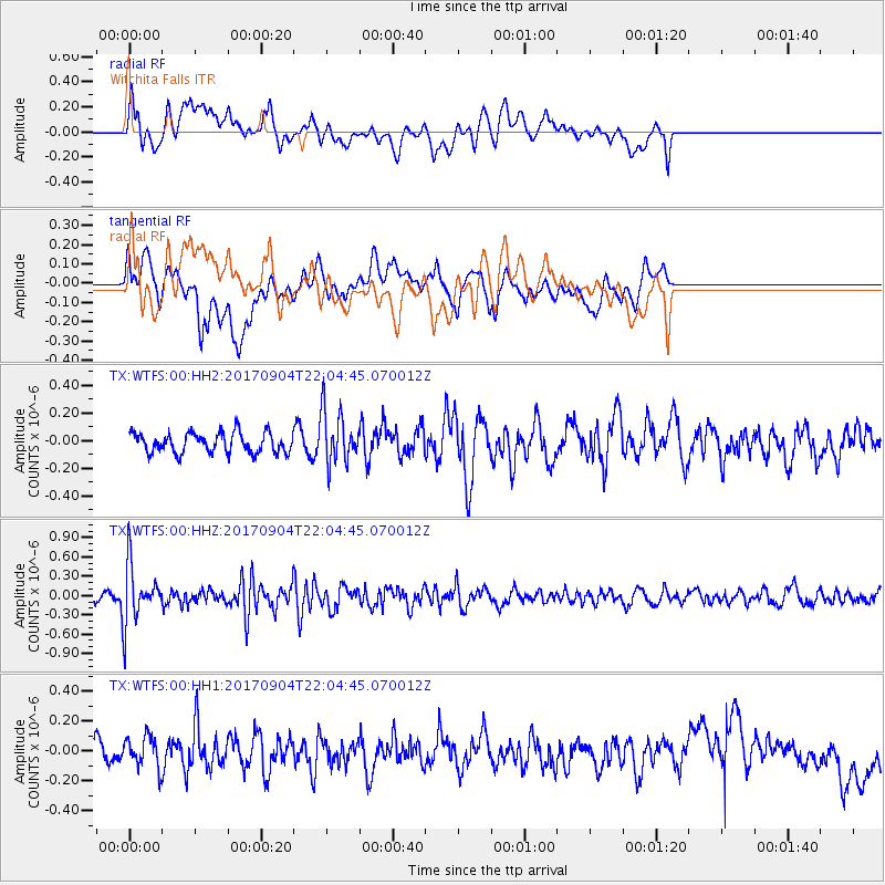
WTFS Witchita Falls - Earthquake Result Viewer
*The percent match for this event was below the threshold and hence no stack was calculated.
| Earthquake location: |
Near Coast Of Northern Chile |
| Earthquake latitude/longitude: |
-19.3/-70.0 |
| Earthquake time(UTC): |
2017/09/04 (247) 21:55:20 GMT |
| Earthquake Depth: |
63 km |
| Earthquake Magnitude: |
5.1 Mwr |
| Earthquake Catalog/Contributor: |
NEIC PDE/us |
|
| Network: |
TX Texas Seismological Network |
| Station: |
WTFS Witchita Falls |
| Lat/Lon: |
33.77 N/98.46 W |
| Elevation: |
277 m |
|
| Distance: |
59.3 deg |
| Az: |
332.54 deg |
| Baz: |
148.477 deg |
| Ray Param: |
$rayparam |
*The percent match for this event was below the threshold and hence was not used in the summary stack. |
|
| Radial Match: |
50.014664 % |
| Radial Bump: |
400 |
| Transverse Match: |
44.805164 % |
| Transverse Bump: |
400 |
| SOD ConfigId: |
2307692 |
| Insert Time: |
2017-09-18 22:01:41.540 +0000 |
| GWidth: |
2.5 |
| Max Bumps: |
400 |
| Tol: |
0.001 |
|
Signal To Noise
| Channel | StoN | STA | LTA |
| TX:WTFS:00:HHZ:20170904T22:04:45.070012Z | 5.2623806 | 4.5573825E-7 | 8.660306E-8 |
| TX:WTFS:00:HH1:20170904T22:04:45.070012Z | 1.2917786 | 1.0762166E-7 | 8.331277E-8 |
| TX:WTFS:00:HH2:20170904T22:04:45.070012Z | 2.6673512 | 1.9121245E-7 | 7.168626E-8 |
| Arrivals |
| Ps | |
| PpPs | |
| PsPs/PpSs | |


