You are here: Home > Network List > TA - USArray Transportable Network (new EarthScope stations) Stations List
> Station D23K Nanushuk River, AK USA > Earthquake Result Viewer
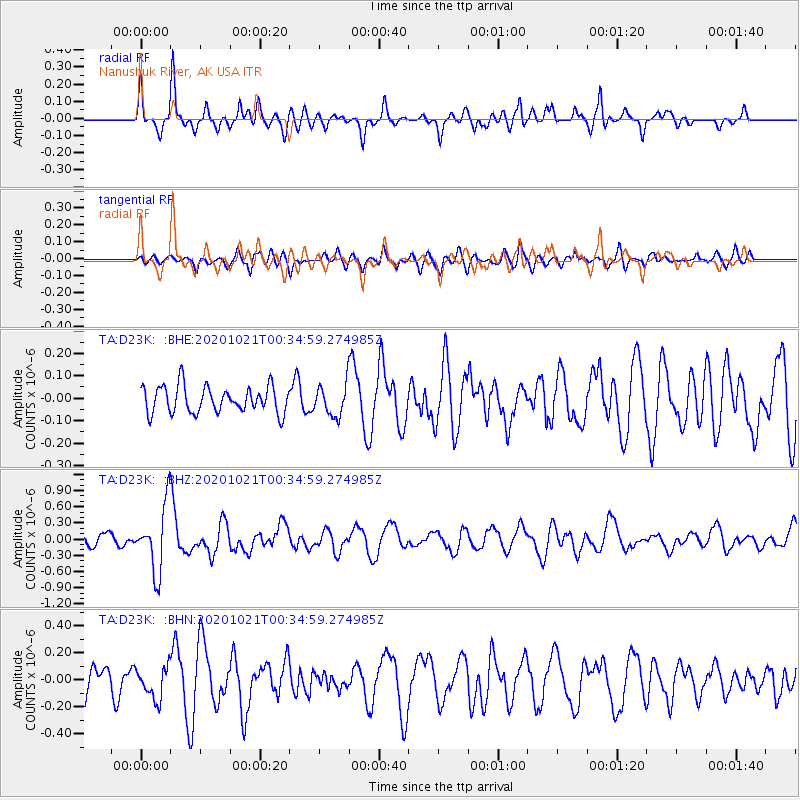
D23K Nanushuk River, AK USA - Earthquake Result Viewer
*The percent match for this event was below the threshold and hence no stack was calculated.
| Earthquake location: |
Tonga Islands Region |
| Earthquake latitude/longitude: |
-19.3/-172.4 |
| Earthquake time(UTC): |
2020/10/21 (295) 00:22:33 GMT |
| Earthquake Depth: |
10 km |
| Earthquake Magnitude: |
5.9 mww |
| Earthquake Catalog/Contributor: |
NEIC PDE/us |
|
| Network: |
TA USArray Transportable Network (new EarthScope stations) |
| Station: |
D23K Nanushuk River, AK USA |
| Lat/Lon: |
68.97 N/150.68 W |
| Elevation: |
406 m |
|
| Distance: |
89.4 deg |
| Az: |
7.674 deg |
| Baz: |
200.446 deg |
| Ray Param: |
$rayparam |
*The percent match for this event was below the threshold and hence was not used in the summary stack. |
|
| Radial Match: |
70.88068 % |
| Radial Bump: |
400 |
| Transverse Match: |
56.383476 % |
| Transverse Bump: |
400 |
| SOD ConfigId: |
22732711 |
| Insert Time: |
2020-11-04 00:45:17.760 +0000 |
| GWidth: |
2.5 |
| Max Bumps: |
400 |
| Tol: |
0.001 |
|
Signal To Noise
| Channel | StoN | STA | LTA |
| TA:D23K: :BHZ:20201021T00:34:59.274985Z | 4.1972337 | 6.1623075E-7 | 1.4681831E-7 |
| TA:D23K: :BHN:20201021T00:34:59.274985Z | 1.541159 | 1.18079214E-7 | 7.661715E-8 |
| TA:D23K: :BHE:20201021T00:34:59.274985Z | 1.1814488 | 6.972924E-8 | 5.9020106E-8 |
| Arrivals |
| Ps | |
| PpPs | |
| PsPs/PpSs | |


