You are here: Home > Network List > TA - USArray Transportable Network (new EarthScope stations) Stations List
> Station F24K Squaw Lake, AK, USA > Earthquake Result Viewer
F24K Squaw Lake, AK, USA - Earthquake Result Viewer
| Earthquake location: |
Tonga Islands Region |
| Earthquake latitude/longitude: |
-19.3/-172.4 |
| Earthquake time(UTC): |
2020/10/21 (295) 00:22:33 GMT |
| Earthquake Depth: |
10 km |
| Earthquake Magnitude: |
5.9 mww |
| Earthquake Catalog/Contributor: |
NEIC PDE/us |
|
| Network: |
TA USArray Transportable Network (new EarthScope stations) |
| Station: |
F24K Squaw Lake, AK, USA |
| Lat/Lon: |
67.52 N/147.89 W |
| Elevation: |
736 m |
|
| Distance: |
88.5 deg |
| Az: |
9.181 deg |
| Baz: |
203.066 deg |
| Ray Param: |
0.042573262 |
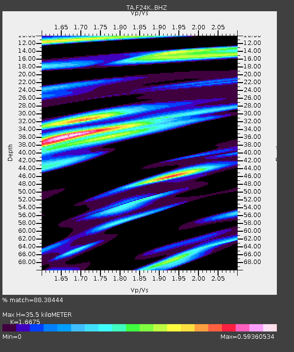
| Estimated Moho Depth: |
35.5 km |
| Estimated Crust Vp/Vs: |
1.67 |
| Assumed Crust Vp: |
6.522 km/s |
| Estimated Crust Vs: |
3.911 km/s |
| Estimated Crust Poisson's Ratio: |
0.22 |
|
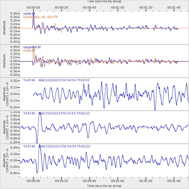
| Radial Match: |
88.38444 % |
| Radial Bump: |
400 |
| Transverse Match: |
74.05379 % |
| Transverse Bump: |
365 |
| SOD ConfigId: |
22732711 |
| Insert Time: |
2020-11-04 00:45:35.588 +0000 |
| GWidth: |
2.5 |
| Max Bumps: |
400 |
| Tol: |
0.001 |
|
Signal To Noise
| Channel | StoN | STA | LTA |
| TA:F24K: :BHZ:20201021T00:34:54.750021Z | 7.195792 | 6.791951E-7 | 9.4387815E-8 |
| TA:F24K: :BHN:20201021T00:34:54.750021Z | 6.9702377 | 2.4933544E-7 | 3.577144E-8 |
| TA:F24K: :BHE:20201021T00:34:54.750021Z | 0.9659515 | 5.612852E-8 | 5.8106977E-8 |
| Arrivals |
| Ps | 3.7 SECOND |
| PpPs | 14 SECOND |
| PsPs/PpSs | 18 SECOND |


