You are here: Home > Network List > TA - USArray Transportable Network (new EarthScope stations) Stations List
> Station G31M Satah River, YT, CAN > Earthquake Result Viewer
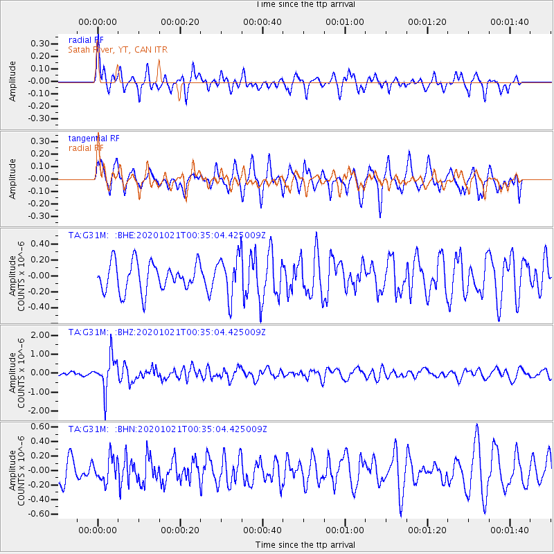
G31M Satah River, YT, CAN - Earthquake Result Viewer
*The percent match for this event was below the threshold and hence no stack was calculated.
| Earthquake location: |
Tonga Islands Region |
| Earthquake latitude/longitude: |
-19.3/-172.4 |
| Earthquake time(UTC): |
2020/10/21 (295) 00:22:33 GMT |
| Earthquake Depth: |
10 km |
| Earthquake Magnitude: |
5.9 mww |
| Earthquake Catalog/Contributor: |
NEIC PDE/us |
|
| Network: |
TA USArray Transportable Network (new EarthScope stations) |
| Station: |
G31M Satah River, YT, CAN |
| Lat/Lon: |
66.92 N/134.27 W |
| Elevation: |
61 m |
|
| Distance: |
90.5 deg |
| Az: |
14.084 deg |
| Baz: |
215.66 deg |
| Ray Param: |
$rayparam |
*The percent match for this event was below the threshold and hence was not used in the summary stack. |
|
| Radial Match: |
60.311344 % |
| Radial Bump: |
400 |
| Transverse Match: |
67.86384 % |
| Transverse Bump: |
400 |
| SOD ConfigId: |
22732711 |
| Insert Time: |
2020-11-04 00:45:55.214 +0000 |
| GWidth: |
2.5 |
| Max Bumps: |
400 |
| Tol: |
0.001 |
|
Signal To Noise
| Channel | StoN | STA | LTA |
| TA:G31M: :BHZ:20201021T00:35:04.425009Z | 6.61833 | 9.007002E-7 | 1.3609176E-7 |
| TA:G31M: :BHN:20201021T00:35:04.425009Z | 0.96513253 | 1.6605486E-7 | 1.7205394E-7 |
| TA:G31M: :BHE:20201021T00:35:04.425009Z | 1.4971509 | 2.692988E-7 | 1.7987418E-7 |
| Arrivals |
| Ps | |
| PpPs | |
| PsPs/PpSs | |


