You are here: Home > Network List > TA - USArray Transportable Network (new EarthScope stations) Stations List
> Station J18K Innoko River, AK, USA > Earthquake Result Viewer
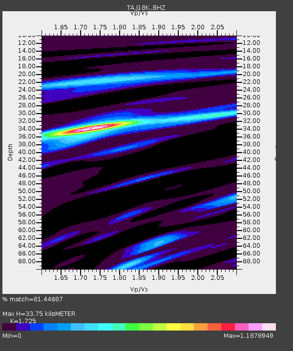
J18K Innoko River, AK, USA - Earthquake Result Viewer
| Earthquake location: |
Tonga Islands Region |
| Earthquake latitude/longitude: |
-19.3/-172.4 |
| Earthquake time(UTC): |
2020/10/21 (295) 00:22:33 GMT |
| Earthquake Depth: |
10 km |
| Earthquake Magnitude: |
5.9 mww |
| Earthquake Catalog/Contributor: |
NEIC PDE/us |
|
| Network: |
TA USArray Transportable Network (new EarthScope stations) |
| Station: |
J18K Innoko River, AK, USA |
| Lat/Lon: |
63.47 N/156.72 W |
| Elevation: |
506 m |
|
| Distance: |
83.4 deg |
| Az: |
7.016 deg |
| Baz: |
194.881 deg |
| Ray Param: |
0.046204638 |
| Estimated Moho Depth: |
33.75 km |
| Estimated Crust Vp/Vs: |
1.73 |
| Assumed Crust Vp: |
6.182 km/s |
| Estimated Crust Vs: |
3.584 km/s |
| Estimated Crust Poisson's Ratio: |
0.25 |
|
| Radial Match: |
81.44687 % |
| Radial Bump: |
351 |
| Transverse Match: |
68.05793 % |
| Transverse Bump: |
400 |
| SOD ConfigId: |
22732711 |
| Insert Time: |
2020-11-04 00:46:14.986 +0000 |
| GWidth: |
2.5 |
| Max Bumps: |
400 |
| Tol: |
0.001 |
|

Signal To Noise
| Channel | StoN | STA | LTA |
| TA:J18K: :BHZ:20201021T00:34:29.925009Z | 14.926519 | 9.129601E-7 | 6.116363E-8 |
| TA:J18K: :BHN:20201021T00:34:29.925009Z | 4.0552893 | 3.6154648E-7 | 8.91543E-8 |
| TA:J18K: :BHE:20201021T00:34:29.925009Z | 2.0191565 | 1.3499178E-7 | 6.6855534E-8 |
| Arrivals |
| Ps | 4.1 SECOND |
| PpPs | 15 SECOND |
| PsPs/PpSs | 19 SECOND |


