You are here: Home > Network List > TA - USArray Transportable Network (new EarthScope stations) Stations List
> Station R33M Jennings River, BC, CAN > Earthquake Result Viewer
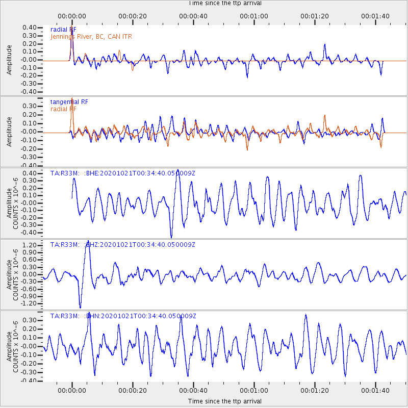
R33M Jennings River, BC, CAN - Earthquake Result Viewer
*The percent match for this event was below the threshold and hence no stack was calculated.
| Earthquake location: |
Tonga Islands Region |
| Earthquake latitude/longitude: |
-19.3/-172.4 |
| Earthquake time(UTC): |
2020/10/21 (295) 00:22:33 GMT |
| Earthquake Depth: |
10 km |
| Earthquake Magnitude: |
5.9 mww |
| Earthquake Catalog/Contributor: |
NEIC PDE/us |
|
| Network: |
TA USArray Transportable Network (new EarthScope stations) |
| Station: |
R33M Jennings River, BC, CAN |
| Lat/Lon: |
59.39 N/130.97 W |
| Elevation: |
1437 m |
|
| Distance: |
85.4 deg |
| Az: |
19.852 deg |
| Baz: |
218.814 deg |
| Ray Param: |
$rayparam |
*The percent match for this event was below the threshold and hence was not used in the summary stack. |
|
| Radial Match: |
60.013943 % |
| Radial Bump: |
353 |
| Transverse Match: |
68.96147 % |
| Transverse Bump: |
400 |
| SOD ConfigId: |
22732711 |
| Insert Time: |
2020-11-04 00:46:59.589 +0000 |
| GWidth: |
2.5 |
| Max Bumps: |
400 |
| Tol: |
0.001 |
|
Signal To Noise
| Channel | StoN | STA | LTA |
| TA:R33M: :BHZ:20201021T00:34:40.050009Z | 5.5984397 | 6.443456E-7 | 1.1509378E-7 |
| TA:R33M: :BHN:20201021T00:34:40.050009Z | 0.96142 | 7.924534E-8 | 8.24253E-8 |
| TA:R33M: :BHE:20201021T00:34:40.050009Z | 1.7755253 | 2.1995166E-7 | 1.2387977E-7 |
| Arrivals |
| Ps | |
| PpPs | |
| PsPs/PpSs | |


