You are here: Home > Network List > TX - Texas Seismological Network Stations List
> Station SN07 Snyder 07 > Earthquake Result Viewer
SN07 Snyder 07 - Earthquake Result Viewer
| Earthquake location: |
Tonga Islands Region |
| Earthquake latitude/longitude: |
-19.3/-172.4 |
| Earthquake time(UTC): |
2020/10/21 (295) 00:22:33 GMT |
| Earthquake Depth: |
10 km |
| Earthquake Magnitude: |
5.9 mww |
| Earthquake Catalog/Contributor: |
NEIC PDE/us |
|
| Network: |
TX Texas Seismological Network |
| Station: |
SN07 Snyder 07 |
| Lat/Lon: |
33.09 N/100.89 W |
| Elevation: |
620 m |
|
| Distance: |
85.8 deg |
| Az: |
52.959 deg |
| Baz: |
243.89 deg |
| Ray Param: |
0.044492316 |
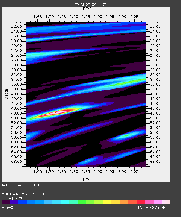
| Estimated Moho Depth: |
47.5 km |
| Estimated Crust Vp/Vs: |
1.72 |
| Assumed Crust Vp: |
6.426 km/s |
| Estimated Crust Vs: |
3.731 km/s |
| Estimated Crust Poisson's Ratio: |
0.25 |
|
| Radial Match: |
81.32709 % |
| Radial Bump: |
400 |
| Transverse Match: |
67.06327 % |
| Transverse Bump: |
400 |
| SOD ConfigId: |
22732711 |
| Insert Time: |
2020-11-04 00:48:47.432 +0000 |
| GWidth: |
2.5 |
| Max Bumps: |
400 |
| Tol: |
0.001 |
|

Signal To Noise
| Channel | StoN | STA | LTA |
| TX:SN07:00:HHZ:20201021T00:34:41.990012Z | 5.199158 | 6.396633E-7 | 1.230321E-7 |
| TX:SN07:00:HH1:20201021T00:34:41.990012Z | 1.6102898 | 9.251249E-8 | 5.7450833E-8 |
| TX:SN07:00:HH2:20201021T00:34:41.990012Z | 1.4909437 | 1.3546894E-7 | 9.08612E-8 |
| Arrivals |
| Ps | 5.5 SECOND |
| PpPs | 20 SECOND |
| PsPs/PpSs | 25 SECOND |


