You are here: Home > Network List > TX - Texas Seismological Network Stations List
> Station SN10 Rotan > Earthquake Result Viewer
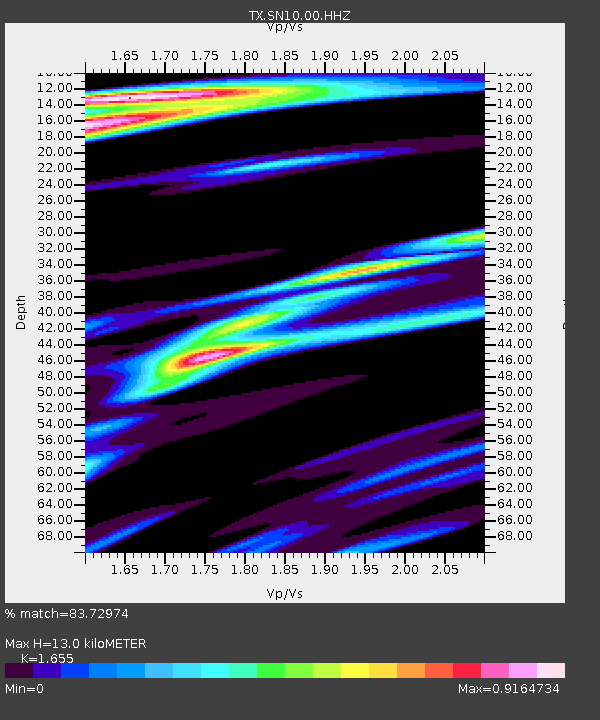
SN10 Rotan - Earthquake Result Viewer
| Earthquake location: |
Tonga Islands Region |
| Earthquake latitude/longitude: |
-19.3/-172.4 |
| Earthquake time(UTC): |
2020/10/21 (295) 00:22:33 GMT |
| Earthquake Depth: |
10 km |
| Earthquake Magnitude: |
5.9 mww |
| Earthquake Catalog/Contributor: |
NEIC PDE/us |
|
| Network: |
TX Texas Seismological Network |
| Station: |
SN10 Rotan |
| Lat/Lon: |
33.05 N/100.72 W |
| Elevation: |
658 m |
|
| Distance: |
85.9 deg |
| Az: |
53.058 deg |
| Baz: |
243.988 deg |
| Ray Param: |
0.044419322 |
| Estimated Moho Depth: |
13.0 km |
| Estimated Crust Vp/Vs: |
1.65 |
| Assumed Crust Vp: |
6.426 km/s |
| Estimated Crust Vs: |
3.883 km/s |
| Estimated Crust Poisson's Ratio: |
0.21 |
|
| Radial Match: |
83.72974 % |
| Radial Bump: |
400 |
| Transverse Match: |
58.039555 % |
| Transverse Bump: |
400 |
| SOD ConfigId: |
22732711 |
| Insert Time: |
2020-11-04 00:48:51.879 +0000 |
| GWidth: |
2.5 |
| Max Bumps: |
400 |
| Tol: |
0.001 |
|

Signal To Noise
| Channel | StoN | STA | LTA |
| TX:SN10:00:HHZ:20201021T00:34:42.52999Z | 5.2342277 | 6.2328144E-7 | 1.1907802E-7 |
| TX:SN10:00:HH1:20201021T00:34:42.52999Z | 2.6402779 | 2.1455376E-7 | 8.126181E-8 |
| TX:SN10:00:HH2:20201021T00:34:42.52999Z | 1.8666776 | 1.8809024E-7 | 1.0076204E-7 |
| Arrivals |
| Ps | 1.4 SECOND |
| PpPs | 5.2 SECOND |
| PsPs/PpSs | 6.6 SECOND |


