You are here: Home > Network List > US - United States National Seismic Network Stations List
> Station SCIA State Center, Iowa, USA > Earthquake Result Viewer
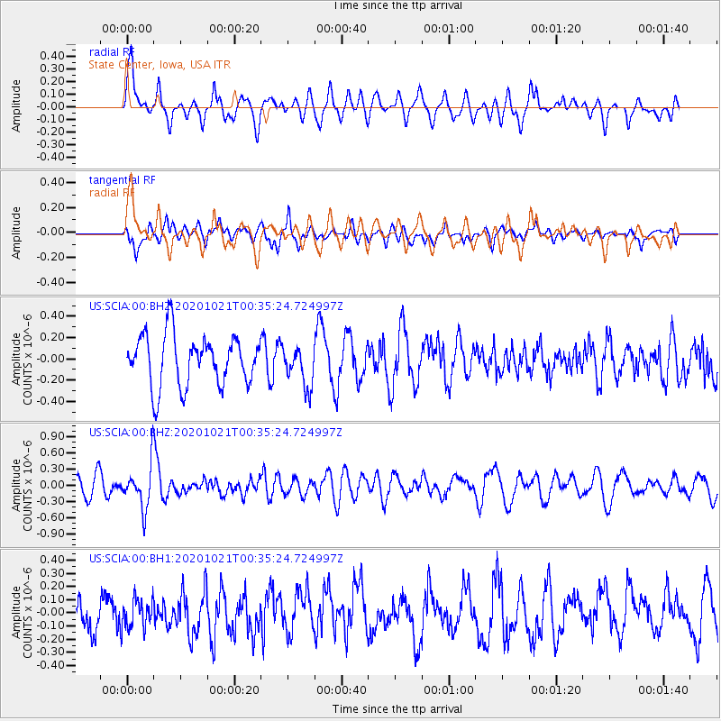
SCIA State Center, Iowa, USA - Earthquake Result Viewer
*The percent match for this event was below the threshold and hence no stack was calculated.
| Earthquake location: |
Tonga Islands Region |
| Earthquake latitude/longitude: |
-19.3/-172.4 |
| Earthquake time(UTC): |
2020/10/21 (295) 00:22:33 GMT |
| Earthquake Depth: |
10 km |
| Earthquake Magnitude: |
5.9 mww |
| Earthquake Catalog/Contributor: |
NEIC PDE/us |
|
| Network: |
US United States National Seismic Network |
| Station: |
SCIA State Center, Iowa, USA |
| Lat/Lon: |
41.91 N/93.22 W |
| Elevation: |
312 m |
|
| Distance: |
95.0 deg |
| Az: |
47.385 deg |
| Baz: |
248.599 deg |
| Ray Param: |
$rayparam |
*The percent match for this event was below the threshold and hence was not used in the summary stack. |
|
| Radial Match: |
60.097626 % |
| Radial Bump: |
400 |
| Transverse Match: |
53.053585 % |
| Transverse Bump: |
400 |
| SOD ConfigId: |
22732711 |
| Insert Time: |
2020-11-04 00:50:18.893 +0000 |
| GWidth: |
2.5 |
| Max Bumps: |
400 |
| Tol: |
0.001 |
|
Signal To Noise
| Channel | StoN | STA | LTA |
| US:SCIA:00:BHZ:20201021T00:35:24.724997Z | 2.5268013 | 4.0378367E-7 | 1.5980032E-7 |
| US:SCIA:00:BH1:20201021T00:35:24.724997Z | 0.73199636 | 1.0766879E-7 | 1.4708924E-7 |
| US:SCIA:00:BH2:20201021T00:35:24.724997Z | 0.7914519 | 1.8753896E-7 | 2.369556E-7 |
| Arrivals |
| Ps | |
| PpPs | |
| PsPs/PpSs | |


