You are here: Home > Network List > UW - Pacific Northwest Regional Seismic Network Stations List
> Station YACT Amboy, WA, USA > Earthquake Result Viewer
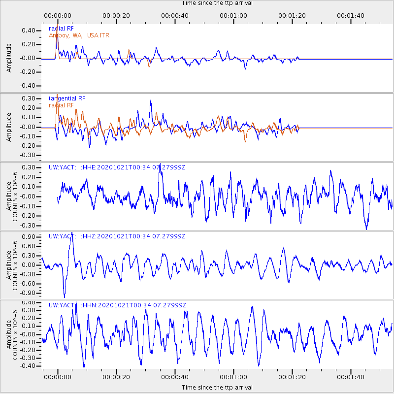
YACT Amboy, WA, USA - Earthquake Result Viewer
*The percent match for this event was below the threshold and hence no stack was calculated.
| Earthquake location: |
Tonga Islands Region |
| Earthquake latitude/longitude: |
-19.3/-172.4 |
| Earthquake time(UTC): |
2020/10/21 (295) 00:22:33 GMT |
| Earthquake Depth: |
10 km |
| Earthquake Magnitude: |
5.9 mww |
| Earthquake Catalog/Contributor: |
NEIC PDE/us |
|
| Network: |
UW Pacific Northwest Regional Seismic Network |
| Station: |
YACT Amboy, WA, USA |
| Lat/Lon: |
45.93 N/122.42 W |
| Elevation: |
211 m |
|
| Distance: |
79.1 deg |
| Az: |
32.966 deg |
| Baz: |
227.417 deg |
| Ray Param: |
$rayparam |
*The percent match for this event was below the threshold and hence was not used in the summary stack. |
|
| Radial Match: |
52.78048 % |
| Radial Bump: |
400 |
| Transverse Match: |
53.228096 % |
| Transverse Bump: |
400 |
| SOD ConfigId: |
22732711 |
| Insert Time: |
2020-11-04 00:52:38.945 +0000 |
| GWidth: |
2.5 |
| Max Bumps: |
400 |
| Tol: |
0.001 |
|
Signal To Noise
| Channel | StoN | STA | LTA |
| UW:YACT: :HHZ:20201021T00:34:07.27999Z | 3.7669947 | 4.8083405E-7 | 1.2764394E-7 |
| UW:YACT: :HHN:20201021T00:34:07.27999Z | 1.5112773 | 1.3697448E-7 | 9.0634906E-8 |
| UW:YACT: :HHE:20201021T00:34:07.27999Z | 1.7920433 | 1.13260356E-7 | 6.3201796E-8 |
| Arrivals |
| Ps | |
| PpPs | |
| PsPs/PpSs | |


