You are here: Home > Network List > WY - Yellowstone Wyoming Seismic Network Stations List
> Station YHH Holmes Hill, YNP, WY, USA > Earthquake Result Viewer
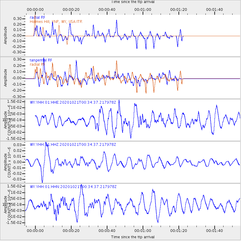
YHH Holmes Hill, YNP, WY, USA - Earthquake Result Viewer
*The percent match for this event was below the threshold and hence no stack was calculated.
| Earthquake location: |
Tonga Islands Region |
| Earthquake latitude/longitude: |
-19.3/-172.4 |
| Earthquake time(UTC): |
2020/10/21 (295) 00:22:33 GMT |
| Earthquake Depth: |
10 km |
| Earthquake Magnitude: |
5.9 mww |
| Earthquake Catalog/Contributor: |
NEIC PDE/us |
|
| Network: |
WY Yellowstone Wyoming Seismic Network |
| Station: |
YHH Holmes Hill, YNP, WY, USA |
| Lat/Lon: |
44.79 N/110.85 W |
| Elevation: |
2717 m |
|
| Distance: |
84.9 deg |
| Az: |
38.942 deg |
| Baz: |
236.469 deg |
| Ray Param: |
$rayparam |
*The percent match for this event was below the threshold and hence was not used in the summary stack. |
|
| Radial Match: |
69.10515 % |
| Radial Bump: |
400 |
| Transverse Match: |
65.11239 % |
| Transverse Bump: |
400 |
| SOD ConfigId: |
22732711 |
| Insert Time: |
2020-11-04 00:52:52.718 +0000 |
| GWidth: |
2.5 |
| Max Bumps: |
400 |
| Tol: |
0.001 |
|
Signal To Noise
| Channel | StoN | STA | LTA |
| WY:YHH:01:HHZ:20201021T00:34:37.217978Z | 4.4810724 | 1.35575124E-8 | 3.025506E-9 |
| WY:YHH:01:HHN:20201021T00:34:37.217978Z | 0.6722836 | 1.7118381E-9 | 2.5463034E-9 |
| WY:YHH:01:HHE:20201021T00:34:37.217978Z | 1.2040256 | 3.3372642E-9 | 2.771755E-9 |
| Arrivals |
| Ps | |
| PpPs | |
| PsPs/PpSs | |


