You are here: Home > Network List > GS - US Geological Survey Networks Stations List
> Station MT01 Lincoln Ranger Stn, Helena Natl Forest, Montana, USA > Earthquake Result Viewer
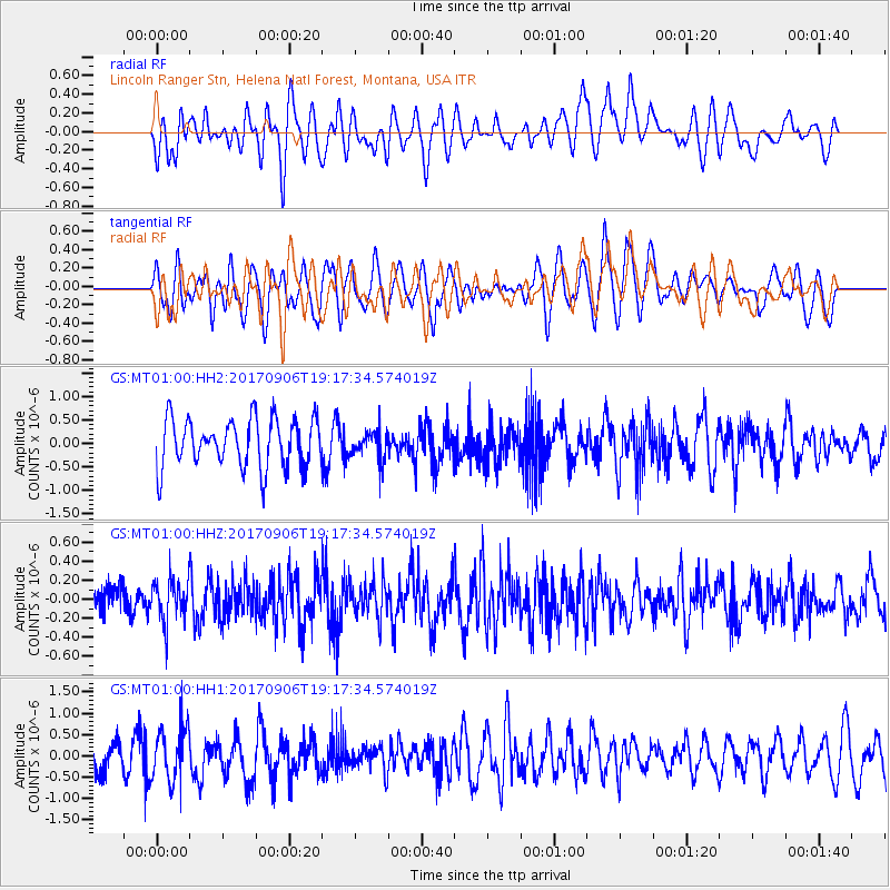
MT01 Lincoln Ranger Stn, Helena Natl Forest, Montana, USA - Earthquake Result Viewer
*The percent match for this event was below the threshold and hence no stack was calculated.
| Earthquake location: |
Tonga Islands |
| Earthquake latitude/longitude: |
-15.4/-173.6 |
| Earthquake time(UTC): |
2017/09/06 (249) 19:05:48 GMT |
| Earthquake Depth: |
56 km |
| Earthquake Magnitude: |
5.1 mb |
| Earthquake Catalog/Contributor: |
NEIC PDE/us |
|
| Network: |
GS US Geological Survey Networks |
| Station: |
MT01 Lincoln Ranger Stn, Helena Natl Forest, Montana, USA |
| Lat/Lon: |
46.95 N/112.66 W |
| Elevation: |
1318 m |
|
| Distance: |
82.6 deg |
| Az: |
37.164 deg |
| Baz: |
238.275 deg |
| Ray Param: |
$rayparam |
*The percent match for this event was below the threshold and hence was not used in the summary stack. |
|
| Radial Match: |
48.832497 % |
| Radial Bump: |
400 |
| Transverse Match: |
52.99764 % |
| Transverse Bump: |
400 |
| SOD ConfigId: |
2307692 |
| Insert Time: |
2017-09-20 19:23:51.364 +0000 |
| GWidth: |
2.5 |
| Max Bumps: |
400 |
| Tol: |
0.001 |
|
Signal To Noise
| Channel | StoN | STA | LTA |
| GS:MT01:00:HHZ:20170906T19:17:34.574019Z | 1.4662849 | 2.202253E-7 | 1.5019272E-7 |
| GS:MT01:00:HH1:20170906T19:17:34.574019Z | 1.3295201 | 6.114357E-7 | 4.5989205E-7 |
| GS:MT01:00:HH2:20170906T19:17:34.574019Z | 0.5436691 | 2.821749E-7 | 5.190196E-7 |
| Arrivals |
| Ps | |
| PpPs | |
| PsPs/PpSs | |


