You are here: Home > Network List > LD - Lamont-Doherty Cooperative Seismographic Network Stations List
> Station FRNY Flat Rock, Altona, NY > Earthquake Result Viewer
FRNY Flat Rock, Altona, NY - Earthquake Result Viewer
| Earthquake location: |
Central Mid-Atlantic Ridge |
| Earthquake latitude/longitude: |
8.1/-38.7 |
| Earthquake time(UTC): |
2008/09/10 (254) 13:08:14 GMT |
| Earthquake Depth: |
10 km |
| Earthquake Magnitude: |
6.3 MB, 6.5 MS, 6.6 MW, 6.6 MW |
| Earthquake Catalog/Contributor: |
WHDF/NEIC |
|
| Network: |
LD Lamont-Doherty Cooperative Seismographic Network |
| Station: |
FRNY Flat Rock, Altona, NY |
| Lat/Lon: |
44.83 N/73.59 W |
| Elevation: |
242 m |
|
| Distance: |
47.4 deg |
| Az: |
326.481 deg |
| Baz: |
129.782 deg |
| Ray Param: |
0.06998416 |
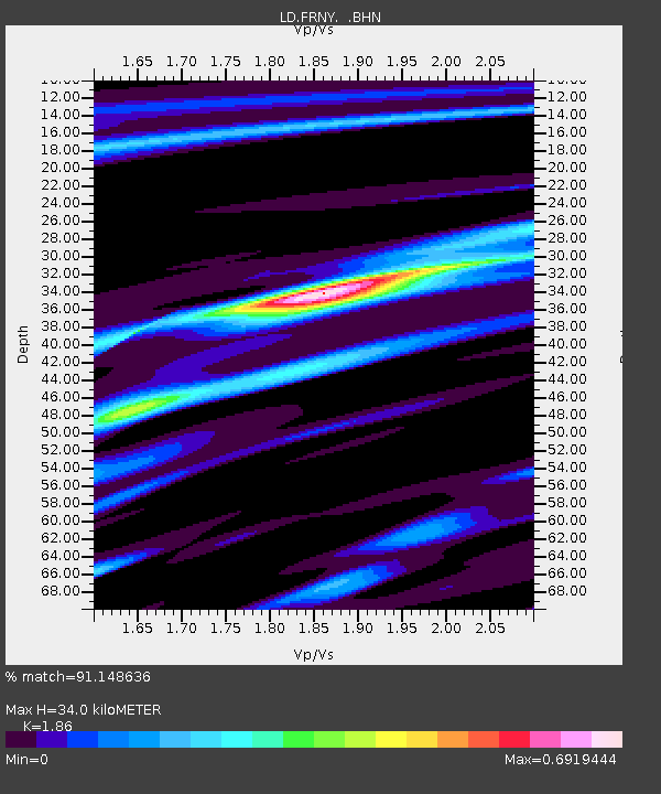
| Estimated Moho Depth: |
34.0 km |
| Estimated Crust Vp/Vs: |
1.86 |
| Assumed Crust Vp: |
6.419 km/s |
| Estimated Crust Vs: |
3.451 km/s |
| Estimated Crust Poisson's Ratio: |
0.30 |
|
| Radial Match: |
91.148636 % |
| Radial Bump: |
231 |
| Transverse Match: |
81.96045 % |
| Transverse Bump: |
400 |
| SOD ConfigId: |
2560 |
| Insert Time: |
2010-03-09 02:29:00.978 +0000 |
| GWidth: |
2.5 |
| Max Bumps: |
400 |
| Tol: |
0.001 |
|

Signal To Noise
| Channel | StoN | STA | LTA |
| LD:FRNY: :BHN:20080910T13:16:18.705013Z | 7.1138434 | 1.3683058E-6 | 1.9234409E-7 |
| LD:FRNY: :BHE:20080910T13:16:18.705013Z | 3.2729855 | 4.1866832E-7 | 1.2791634E-7 |
| LD:FRNY: :BHZ:20080910T13:16:18.705013Z | 4.595214 | 7.515996E-7 | 1.635614E-7 |
| Arrivals |
| Ps | 4.8 SECOND |
| PpPs | 14 SECOND |
| PsPs/PpSs | 19 SECOND |


