You are here: Home > Network List > US - United States National Seismic Network Stations List
> Station AMTX Amarillo, Texas, USA > Earthquake Result Viewer
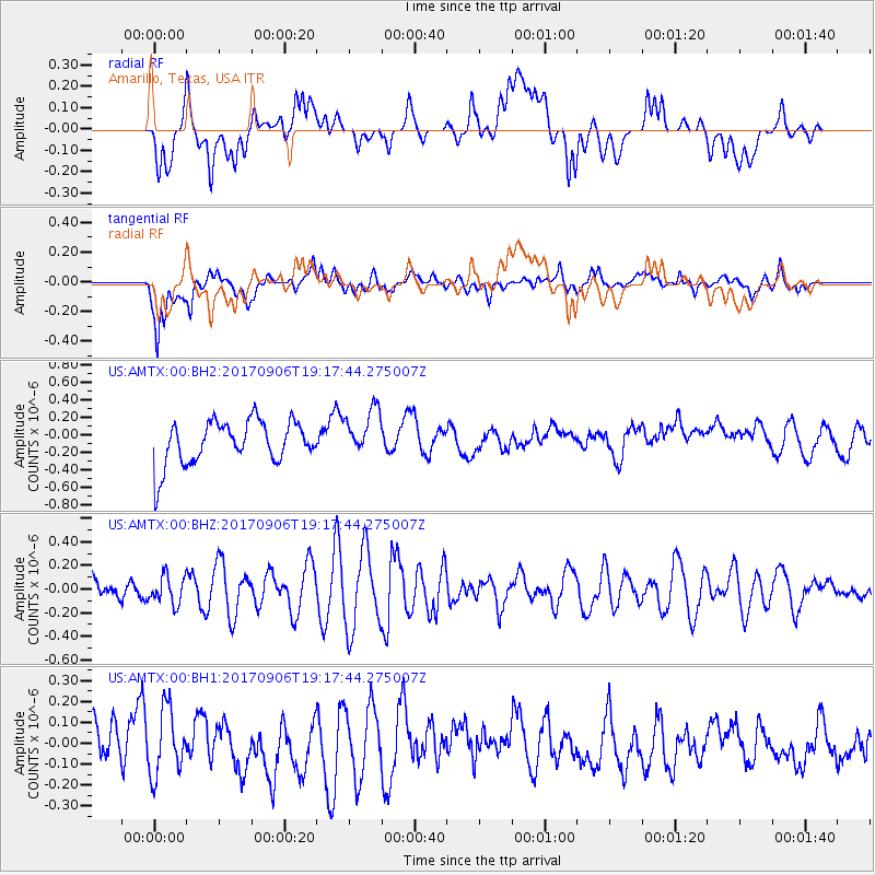
AMTX Amarillo, Texas, USA - Earthquake Result Viewer
*The percent match for this event was below the threshold and hence no stack was calculated.
| Earthquake location: |
Tonga Islands |
| Earthquake latitude/longitude: |
-15.4/-173.6 |
| Earthquake time(UTC): |
2017/09/06 (249) 19:05:48 GMT |
| Earthquake Depth: |
56 km |
| Earthquake Magnitude: |
5.1 mb |
| Earthquake Catalog/Contributor: |
NEIC PDE/us |
|
| Network: |
US United States National Seismic Network |
| Station: |
AMTX Amarillo, Texas, USA |
| Lat/Lon: |
34.53 N/101.41 W |
| Elevation: |
1010 m |
|
| Distance: |
84.6 deg |
| Az: |
52.162 deg |
| Baz: |
247.32 deg |
| Ray Param: |
$rayparam |
*The percent match for this event was below the threshold and hence was not used in the summary stack. |
|
| Radial Match: |
27.348406 % |
| Radial Bump: |
400 |
| Transverse Match: |
64.759605 % |
| Transverse Bump: |
400 |
| SOD ConfigId: |
2307692 |
| Insert Time: |
2017-09-20 19:25:10.175 +0000 |
| GWidth: |
2.5 |
| Max Bumps: |
400 |
| Tol: |
0.001 |
|
Signal To Noise
| Channel | StoN | STA | LTA |
| US:AMTX:00:BHZ:20170906T19:17:44.275007Z | 1.8021002 | 1.17532245E-7 | 6.5219595E-8 |
| US:AMTX:00:BH1:20170906T19:17:44.275007Z | 1.9409679 | 1.5679667E-7 | 8.078272E-8 |
| US:AMTX:00:BH2:20170906T19:17:44.275007Z | 1.1139936 | 2.6147262E-7 | 2.3471645E-7 |
| Arrivals |
| Ps | |
| PpPs | |
| PsPs/PpSs | |


