You are here: Home > Network List > US - United States National Seismic Network Stations List
> Station DUG Dugway, Tooele County, Utah, USA > Earthquake Result Viewer
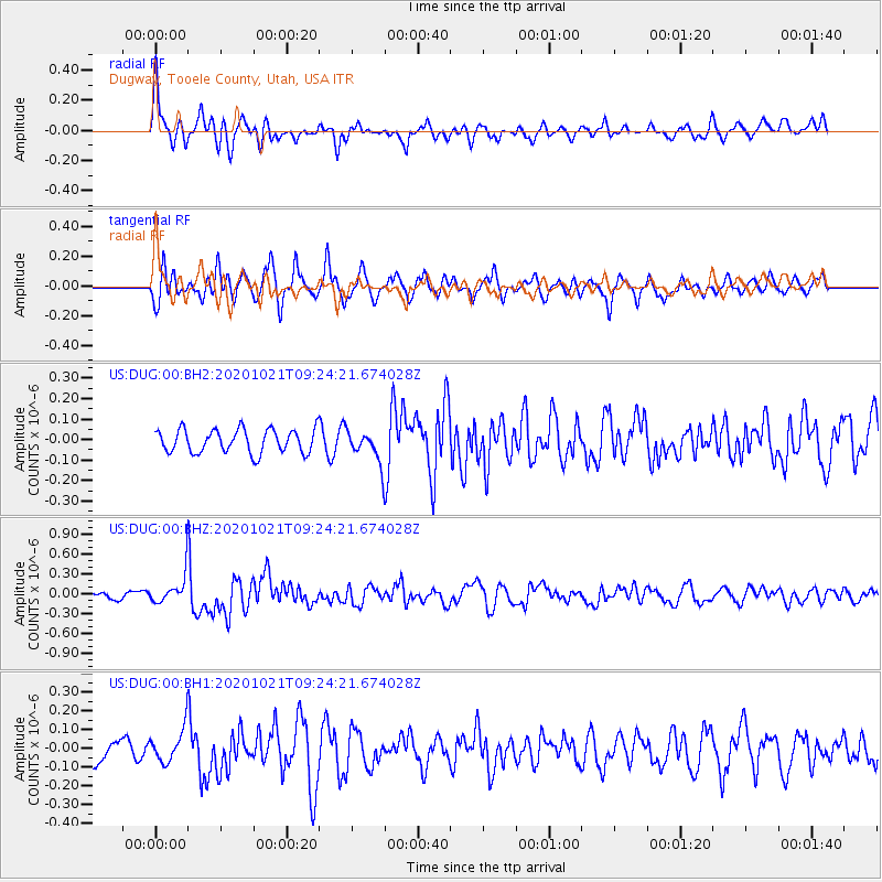
DUG Dugway, Tooele County, Utah, USA - Earthquake Result Viewer
*The percent match for this event was below the threshold and hence no stack was calculated.
| Earthquake location: |
Near Coast Of Northern Chile |
| Earthquake latitude/longitude: |
-25.5/-71.0 |
| Earthquake time(UTC): |
2020/10/21 (295) 09:13:05 GMT |
| Earthquake Depth: |
9.4 km |
| Earthquake Magnitude: |
5.7 Mww |
| Earthquake Catalog/Contributor: |
NEIC PDE/us |
|
| Network: |
US United States National Seismic Network |
| Station: |
DUG Dugway, Tooele County, Utah, USA |
| Lat/Lon: |
40.19 N/112.81 W |
| Elevation: |
1477 m |
|
| Distance: |
76.1 deg |
| Az: |
328.255 deg |
| Baz: |
141.636 deg |
| Ray Param: |
$rayparam |
*The percent match for this event was below the threshold and hence was not used in the summary stack. |
|
| Radial Match: |
73.439354 % |
| Radial Bump: |
400 |
| Transverse Match: |
74.58578 % |
| Transverse Bump: |
400 |
| SOD ConfigId: |
22732711 |
| Insert Time: |
2020-11-04 09:35:02.033 +0000 |
| GWidth: |
2.5 |
| Max Bumps: |
400 |
| Tol: |
0.001 |
|
Signal To Noise
| Channel | StoN | STA | LTA |
| US:DUG:00:BHZ:20201021T09:24:21.674028Z | 4.0535655 | 2.1437756E-7 | 5.2886175E-8 |
| US:DUG:00:BH1:20201021T09:24:21.674028Z | 1.5650957 | 8.9085034E-8 | 5.6919863E-8 |
| US:DUG:00:BH2:20201021T09:24:21.674028Z | 1.3677596 | 7.7995196E-8 | 5.702405E-8 |
| Arrivals |
| Ps | |
| PpPs | |
| PsPs/PpSs | |


