You are here: Home > Network List > UW - Pacific Northwest Regional Seismic Network Stations List
> Station HOOD Mt Hood Meadows, OR CREST BB SMO > Earthquake Result Viewer
HOOD Mt Hood Meadows, OR CREST BB SMO - Earthquake Result Viewer
*The percent match for this event was below the threshold and hence no stack was calculated.
| Earthquake location: |
Near Coast Of Northern Chile |
| Earthquake latitude/longitude: |
-25.5/-71.0 |
| Earthquake time(UTC): |
2020/10/21 (295) 09:13:05 GMT |
| Earthquake Depth: |
9.4 km |
| Earthquake Magnitude: |
5.7 Mww |
| Earthquake Catalog/Contributor: |
NEIC PDE/us |
|
| Network: |
UW Pacific Northwest Regional Seismic Network |
| Station: |
HOOD Mt Hood Meadows, OR CREST BB SMO |
| Lat/Lon: |
45.32 N/121.65 W |
| Elevation: |
1520 m |
|
| Distance: |
84.2 deg |
| Az: |
326.743 deg |
| Baz: |
135.385 deg |
| Ray Param: |
$rayparam |
*The percent match for this event was below the threshold and hence was not used in the summary stack. |
|
| Radial Match: |
36.09365 % |
| Radial Bump: |
400 |
| Transverse Match: |
19.610764 % |
| Transverse Bump: |
349 |
| SOD ConfigId: |
22732711 |
| Insert Time: |
2020-11-04 09:36:53.109 +0000 |
| GWidth: |
2.5 |
| Max Bumps: |
400 |
| Tol: |
0.001 |
|
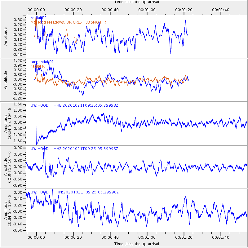
Signal To Noise
| Channel | StoN | STA | LTA |
| UW:HOOD: :HHZ:20201021T09:25:05.39998Z | 3.5323079 | 3.3783783E-7 | 9.564224E-8 |
| UW:HOOD: :HHN:20201021T09:25:05.39998Z | 1.0397267 | 1.1053619E-6 | 1.0631272E-6 |
| UW:HOOD: :HHE:20201021T09:25:05.39998Z | 1.6113226 | 8.828883E-7 | 5.479277E-7 |
| Arrivals |
| Ps | |
| PpPs | |
| PsPs/PpSs | |


