You are here: Home > Network List > II - Global Seismograph Network (GSN - IRIS/IDA) Stations List
> Station WRAB Tennant Creek, NT, Australia > Earthquake Result Viewer
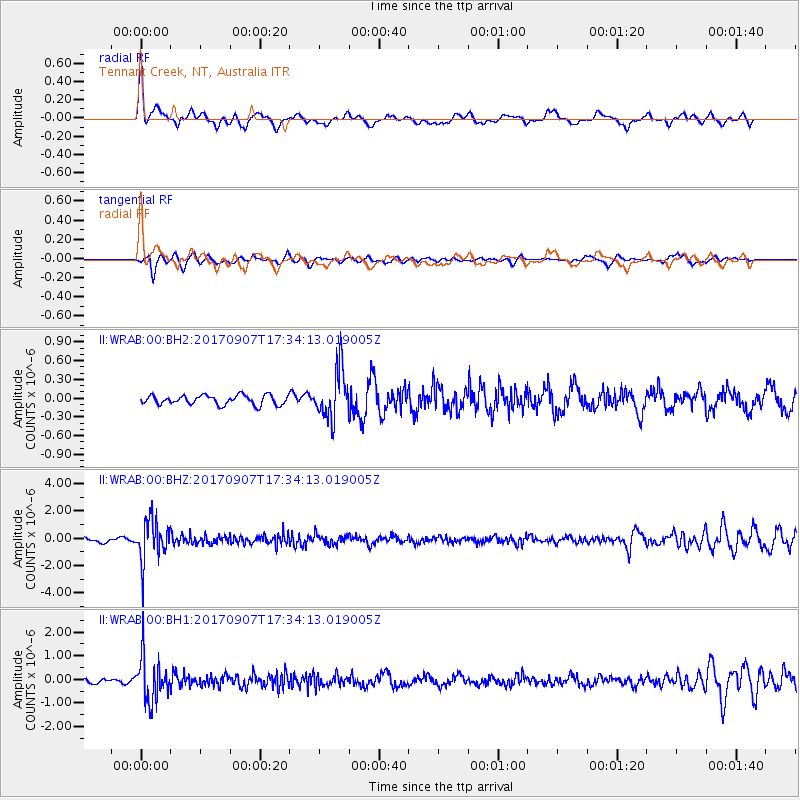
WRAB Tennant Creek, NT, Australia - Earthquake Result Viewer
*The percent match for this event was below the threshold and hence no stack was calculated.
| Earthquake location: |
Bonin Islands, Japan Region |
| Earthquake latitude/longitude: |
27.8/139.8 |
| Earthquake time(UTC): |
2017/09/07 (250) 17:26:49 GMT |
| Earthquake Depth: |
448 km |
| Earthquake Magnitude: |
6.1 Mww |
| Earthquake Catalog/Contributor: |
NEIC PDE/us |
|
| Network: |
II Global Seismograph Network (GSN - IRIS/IDA) |
| Station: |
WRAB Tennant Creek, NT, Australia |
| Lat/Lon: |
19.93 S/134.36 E |
| Elevation: |
366 m |
|
| Distance: |
47.7 deg |
| Az: |
186.939 deg |
| Baz: |
6.534 deg |
| Ray Param: |
$rayparam |
*The percent match for this event was below the threshold and hence was not used in the summary stack. |
|
| Radial Match: |
75.65262 % |
| Radial Bump: |
400 |
| Transverse Match: |
51.058186 % |
| Transverse Bump: |
367 |
| SOD ConfigId: |
2307692 |
| Insert Time: |
2017-09-21 17:32:50.905 +0000 |
| GWidth: |
2.5 |
| Max Bumps: |
400 |
| Tol: |
0.001 |
|
Signal To Noise
| Channel | StoN | STA | LTA |
| II:WRAB:00:BHZ:20170907T17:34:13.019005Z | 7.014375 | 1.4792105E-6 | 2.1088272E-7 |
| II:WRAB:00:BH1:20170907T17:34:13.019005Z | 8.717386 | 9.1892827E-7 | 1.05413285E-7 |
| II:WRAB:00:BH2:20170907T17:34:13.019005Z | 5.1231422 | 3.9050641E-7 | 7.6224005E-8 |
| Arrivals |
| Ps | |
| PpPs | |
| PsPs/PpSs | |


