You are here: Home > Network List > AV - Alaska Volcano Observatory Stations List
> Station SPCR Ckakachatna River, Mount Spurr, Alaska > Earthquake Result Viewer
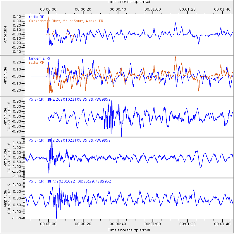
SPCR Ckakachatna River, Mount Spurr, Alaska - Earthquake Result Viewer
*The percent match for this event was below the threshold and hence no stack was calculated.
| Earthquake location: |
Fiji Islands Region |
| Earthquake latitude/longitude: |
-20.9/-176.6 |
| Earthquake time(UTC): |
2020/10/22 (296) 08:24:06 GMT |
| Earthquake Depth: |
236 km |
| Earthquake Magnitude: |
5.7 Mww |
| Earthquake Catalog/Contributor: |
NEIC PDE/us |
|
| Network: |
AV Alaska Volcano Observatory |
| Station: |
SPCR Ckakachatna River, Mount Spurr, Alaska |
| Lat/Lon: |
61.20 N/152.21 W |
| Elevation: |
984 m |
|
| Distance: |
84.1 deg |
| Az: |
11.577 deg |
| Baz: |
202.8 deg |
| Ray Param: |
$rayparam |
*The percent match for this event was below the threshold and hence was not used in the summary stack. |
|
| Radial Match: |
49.5979 % |
| Radial Bump: |
400 |
| Transverse Match: |
54.588234 % |
| Transverse Bump: |
400 |
| SOD ConfigId: |
22732711 |
| Insert Time: |
2020-11-05 08:31:22.370 +0000 |
| GWidth: |
2.5 |
| Max Bumps: |
400 |
| Tol: |
0.001 |
|
Signal To Noise
| Channel | StoN | STA | LTA |
| AV:SPCR: :BHZ:20201022T08:35:39.738995Z | 3.8619335 | 8.2391546E-7 | 2.1334274E-7 |
| AV:SPCR: :BHN:20201022T08:35:39.738995Z | 1.7267914 | 5.0816004E-7 | 2.9427991E-7 |
| AV:SPCR: :BHE:20201022T08:35:39.738995Z | 1.277601 | 3.3393763E-7 | 2.6137866E-7 |
| Arrivals |
| Ps | |
| PpPs | |
| PsPs/PpSs | |


