You are here: Home > Network List > LD - Lamont-Doherty Cooperative Seismographic Network Stations List
> Station MMNY Mount Morris Dam, NY > Earthquake Result Viewer
MMNY Mount Morris Dam, NY - Earthquake Result Viewer
| Earthquake location: |
East Of Kuril Islands |
| Earthquake latitude/longitude: |
46.9/155.2 |
| Earthquake time(UTC): |
2009/01/15 (015) 17:49:39 GMT |
| Earthquake Depth: |
36 km |
| Earthquake Magnitude: |
6.9 MB, 7.5 MS, 7.4 MW, 7.4 MW |
| Earthquake Catalog/Contributor: |
WHDF/NEIC |
|
| Network: |
LD Lamont-Doherty Cooperative Seismographic Network |
| Station: |
MMNY Mount Morris Dam, NY |
| Lat/Lon: |
42.73 N/77.91 W |
| Elevation: |
241 m |
|
| Distance: |
79.2 deg |
| Az: |
36.84 deg |
| Baz: |
326.051 deg |
| Ray Param: |
0.04909191 |
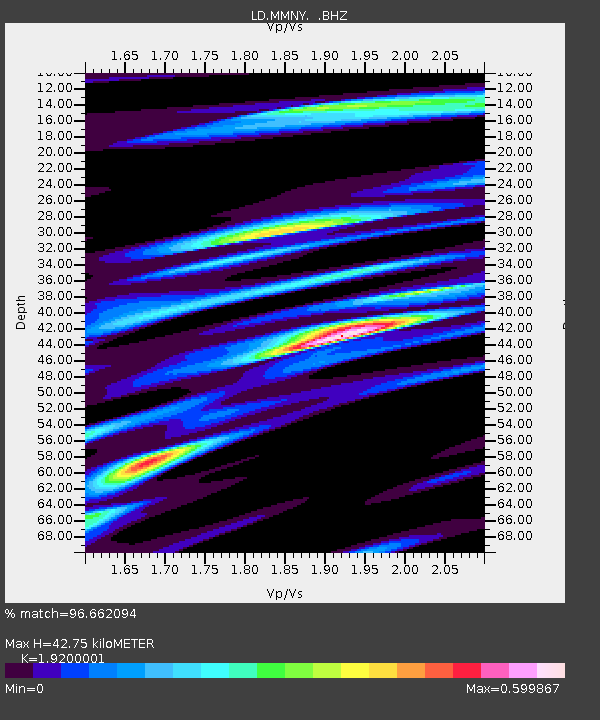
| Estimated Moho Depth: |
42.75 km |
| Estimated Crust Vp/Vs: |
1.92 |
| Assumed Crust Vp: |
6.476 km/s |
| Estimated Crust Vs: |
3.373 km/s |
| Estimated Crust Poisson's Ratio: |
0.31 |
|
| Radial Match: |
96.662094 % |
| Radial Bump: |
395 |
| Transverse Match: |
81.16896 % |
| Transverse Bump: |
400 |
| SOD ConfigId: |
2834 |
| Insert Time: |
2010-03-09 02:53:19.972 +0000 |
| GWidth: |
2.5 |
| Max Bumps: |
400 |
| Tol: |
0.001 |
|

Signal To Noise
| Channel | StoN | STA | LTA |
| LD:MMNY: :BHZ:20090115T18:01:09.200005Z | 9.809028 | 1.7638853E-5 | 1.7982265E-6 |
| LD:MMNY: :BHN:20090115T18:01:09.200005Z | 3.3542402 | 5.8119335E-6 | 1.7327123E-6 |
| LD:MMNY: :BHE:20090115T18:01:09.200005Z | 3.6562889 | 4.2450156E-6 | 1.1610175E-6 |
| Arrivals |
| Ps | 6.2 SECOND |
| PpPs | 19 SECOND |
| PsPs/PpSs | 25 SECOND |


