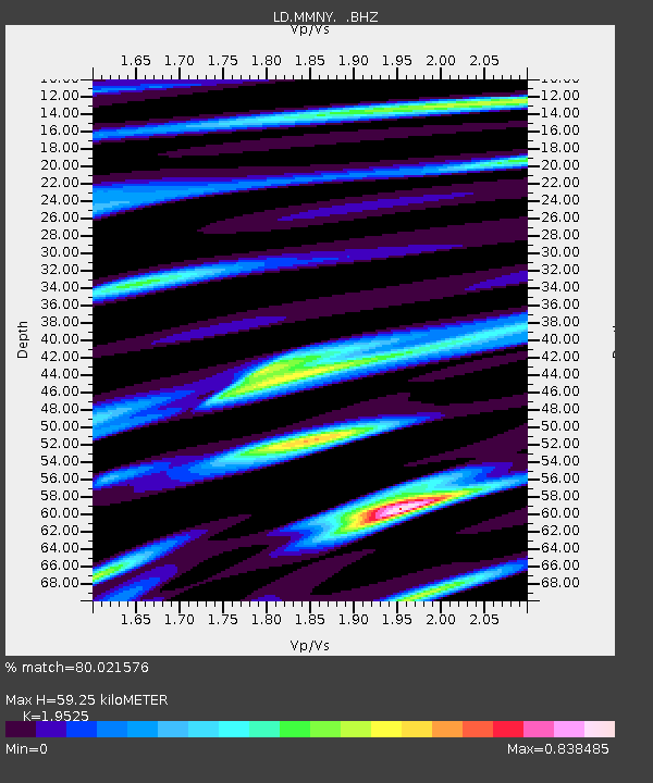
MMNY Mount Morris Dam, NY - Earthquake Result Viewer

Earthquake location: Near Coast Of Central Chile
Earthquake latitude/longitude: -32.5/-71.7
Earthquake time(UTC): 2008/12/18 (353) 21:19:28 GMT
Earthquake Depth: 18 km
Earthquake Magnitude: 5.8 MB, 6.0 MS, 6.2 MW, 6.1 MW
Earthquake Catalog/Contributor: WHDF/NEIC
Network: LD Lamont-Doherty Cooperative Seismographic Network
Station: MMNY Mount Morris Dam, NY
Lat/Lon: 42.73 N/77.91 W
Elevation: 241 m
Distance: 75.0 deg
Az: 355.29 deg
Baz: 174.594 deg
Ray Param: 0.051916968
Estimated Moho Depth: 59.25 km
Estimated Crust Vp/Vs: 1.95
Assumed Crust Vp: 6.476 km/s
Estimated Crust Vs: 3.317 km/s
Estimated Crust Poisson's Ratio: 0.32
Radial Match: 80.021576 %
Radial Bump: 400
Transverse Match: 76.06162 %
Transverse Bump: 400
SOD ConfigId: 2658
Insert Time: 2010-03-09 02:53:40.719 +0000
GWidth: 2.5
Max Bumps: 400
Tol: 0.001

Signal To Noise

ChannelStoNSTALTA
LD:MMNY: :BHZ:20081218T21:30:37.598994Z6.2663732.6531015E-64.233871E-7
LD:MMNY: :BHN:20081218T21:30:37.598994Z3.00155451.3116334E-64.3698466E-7
LD:MMNY: :BHE:20081218T21:30:37.598994Z1.19542543.992703E-73.3399854E-7
Arrivals
Ps9.0 SECOND
PpPs26 SECOND
PsPs/PpSs35 SECOND