You are here: Home > Network List > NN - Western Great Basin/Eastern Sierra Nevada Stations List
> Station RYN Ryan, Nevada w84,gps > Earthquake Result Viewer
RYN Ryan, Nevada w84,gps - Earthquake Result Viewer
| Earthquake location: |
Fiji Islands Region |
| Earthquake latitude/longitude: |
-20.9/-176.6 |
| Earthquake time(UTC): |
2020/10/22 (296) 08:24:06 GMT |
| Earthquake Depth: |
236 km |
| Earthquake Magnitude: |
5.7 Mww |
| Earthquake Catalog/Contributor: |
NEIC PDE/us |
|
| Network: |
NN Western Great Basin/Eastern Sierra Nevada |
| Station: |
RYN Ryan, Nevada w84,gps |
| Lat/Lon: |
38.63 N/118.52 W |
| Elevation: |
1651 m |
|
| Distance: |
80.4 deg |
| Az: |
42.375 deg |
| Baz: |
233.567 deg |
| Ray Param: |
0.04772916 |
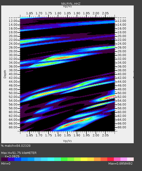
| Estimated Moho Depth: |
51.75 km |
| Estimated Crust Vp/Vs: |
2.09 |
| Assumed Crust Vp: |
6.279 km/s |
| Estimated Crust Vs: |
3.001 km/s |
| Estimated Crust Poisson's Ratio: |
0.35 |
|
| Radial Match: |
84.02328 % |
| Radial Bump: |
313 |
| Transverse Match: |
82.89513 % |
| Transverse Bump: |
324 |
| SOD ConfigId: |
22732711 |
| Insert Time: |
2020-11-05 08:40:42.934 +0000 |
| GWidth: |
2.5 |
| Max Bumps: |
400 |
| Tol: |
0.001 |
|

Signal To Noise
| Channel | StoN | STA | LTA |
| NN:RYN: :HHZ:20201022T08:35:20.369976Z | 2.7598042 | 8.521224E-8 | 3.087619E-8 |
| NN:RYN: :HHN:20201022T08:35:20.369976Z | 0.28495312 | 2.4140792E-8 | 8.471847E-8 |
| NN:RYN: :HHE:20201022T08:35:20.369976Z | 2.6214867 | 2.5941368E-8 | 9.89567E-9 |
| Arrivals |
| Ps | 9.2 SECOND |
| PpPs | 25 SECOND |
| PsPs/PpSs | 34 SECOND |


