You are here: Home > Network List > TA - USArray Transportable Network (new EarthScope stations) Stations List
> Station F26K Sheenjek River, AK, USA > Earthquake Result Viewer
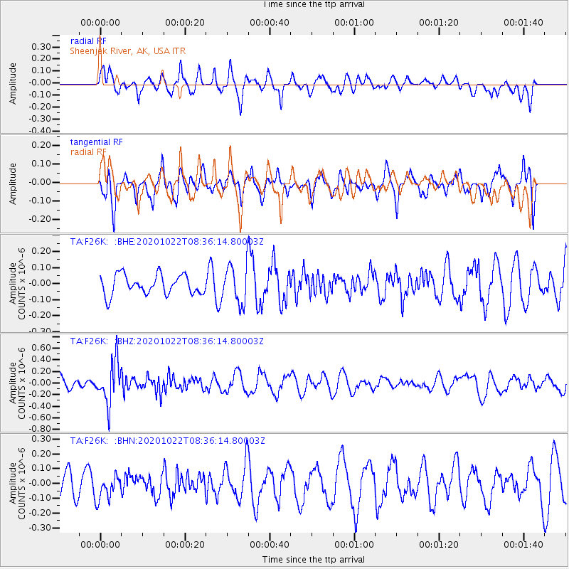
F26K Sheenjek River, AK, USA - Earthquake Result Viewer
*The percent match for this event was below the threshold and hence no stack was calculated.
| Earthquake location: |
Fiji Islands Region |
| Earthquake latitude/longitude: |
-20.9/-176.6 |
| Earthquake time(UTC): |
2020/10/22 (296) 08:24:06 GMT |
| Earthquake Depth: |
236 km |
| Earthquake Magnitude: |
5.7 Mww |
| Earthquake Catalog/Contributor: |
NEIC PDE/us |
|
| Network: |
TA USArray Transportable Network (new EarthScope stations) |
| Station: |
F26K Sheenjek River, AK, USA |
| Lat/Lon: |
67.69 N/144.15 W |
| Elevation: |
683 m |
|
| Distance: |
91.5 deg |
| Az: |
11.811 deg |
| Baz: |
210.089 deg |
| Ray Param: |
$rayparam |
*The percent match for this event was below the threshold and hence was not used in the summary stack. |
|
| Radial Match: |
63.103558 % |
| Radial Bump: |
400 |
| Transverse Match: |
58.970013 % |
| Transverse Bump: |
400 |
| SOD ConfigId: |
22732711 |
| Insert Time: |
2020-11-05 08:44:35.918 +0000 |
| GWidth: |
2.5 |
| Max Bumps: |
400 |
| Tol: |
0.001 |
|
Signal To Noise
| Channel | StoN | STA | LTA |
| TA:F26K: :BHZ:20201022T08:36:14.80003Z | 4.272771 | 3.6637522E-7 | 8.5746514E-8 |
| TA:F26K: :BHN:20201022T08:36:14.80003Z | 1.0142094 | 8.007953E-8 | 7.895759E-8 |
| TA:F26K: :BHE:20201022T08:36:14.80003Z | 2.0131865 | 1.2209554E-7 | 6.0647906E-8 |
| Arrivals |
| Ps | |
| PpPs | |
| PsPs/PpSs | |


