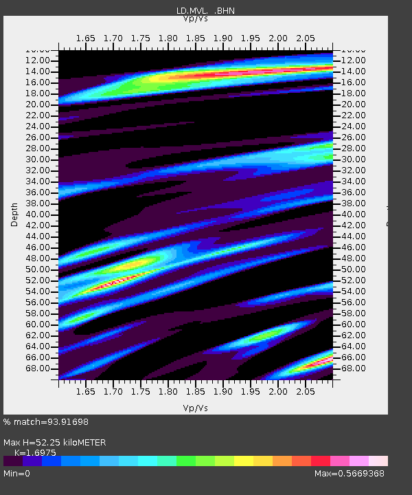
MVL Millersville University, PA - Earthquake Result Viewer

Earthquake location: Near Coast Of Northern Chile
Earthquake latitude/longitude: -20.2/-70.0
Earthquake time(UTC): 2008/02/04 (035) 17:01:30 GMT
Earthquake Depth: 44 km
Earthquake Magnitude: 6.0 MB, 6.2 MS, 6.3 MW, 6.3 MW
Earthquake Catalog/Contributor: WHDF/NEIC
Network: LD Lamont-Doherty Cooperative Seismographic Network
Station: MVL Millersville University, PA
Lat/Lon: 40.00 N/76.35 W
Elevation: 91 m
Distance: 60.1 deg
Az: 354.41 deg
Baz: 173.158 deg
Ray Param: 0.061637223
Estimated Moho Depth: 52.25 km
Estimated Crust Vp/Vs: 1.70
Assumed Crust Vp: 6.419 km/s
Estimated Crust Vs: 3.782 km/s
Estimated Crust Poisson's Ratio: 0.23
Radial Match: 93.91698 %
Radial Bump: 341
Transverse Match: 79.53648 %
Transverse Bump: 400
SOD ConfigId: 2564
Insert Time: 2010-03-09 02:56:04.910 +0000
GWidth: 2.5
Max Bumps: 400
Tol: 0.001

Signal To Noise

ChannelStoNSTALTA
LD:MVL: :BHN:20080204T17:11:03.375029Z13.9215422.379089E-61.7089263E-7
LD:MVL: :BHE:20080204T17:11:03.375029Z3.95220473.8359633E-79.705882E-8
LD:MVL: :BHZ:20080204T17:11:03.375029Z26.0846824.1012468E-61.5722816E-7
Arrivals
Ps6.0 SECOND
PpPs21 SECOND
PsPs/PpSs27 SECOND