You are here: Home > Network List > LD - Lamont-Doherty Cooperative Seismographic Network Stations List
> Station MVL Millersville University, PA > Earthquake Result Viewer
MVL Millersville University, PA - Earthquake Result Viewer

| Earthquake location: |
Peru-Brazil Border Region |
| Earthquake latitude/longitude: |
-7.9/-74.4 |
| Earthquake time(UTC): |
2007/07/12 (193) 05:23:49 GMT |
| Earthquake Depth: |
152 km |
| Earthquake Magnitude: |
5.9 MB, 6.1 MW, 6.0 MW |
| Earthquake Catalog/Contributor: |
WHDF/NEIC |
|
| Network: |
LD Lamont-Doherty Cooperative Seismographic Network |
| Station: |
MVL Millersville University, PA |
| Lat/Lon: |
40.00 N/76.35 W |
| Elevation: |
91 m |
|
| Distance: |
47.7 deg |
| Az: |
357.953 deg |
| Baz: |
177.36 deg |
| Ray Param: |
0.06927489 |
| Estimated Moho Depth: |
53.75 km |
| Estimated Crust Vp/Vs: |
1.66 |
| Assumed Crust Vp: |
6.419 km/s |
| Estimated Crust Vs: |
3.873 km/s |
| Estimated Crust Poisson's Ratio: |
0.21 |
|
| Radial Match: |
87.567154 % |
| Radial Bump: |
348 |
| Transverse Match: |
63.09442 % |
| Transverse Bump: |
400 |
| SOD ConfigId: |
2564 |
| Insert Time: |
2010-03-09 02:56:27.947 +0000 |
| GWidth: |
2.5 |
| Max Bumps: |
400 |
| Tol: |
0.001 |
|
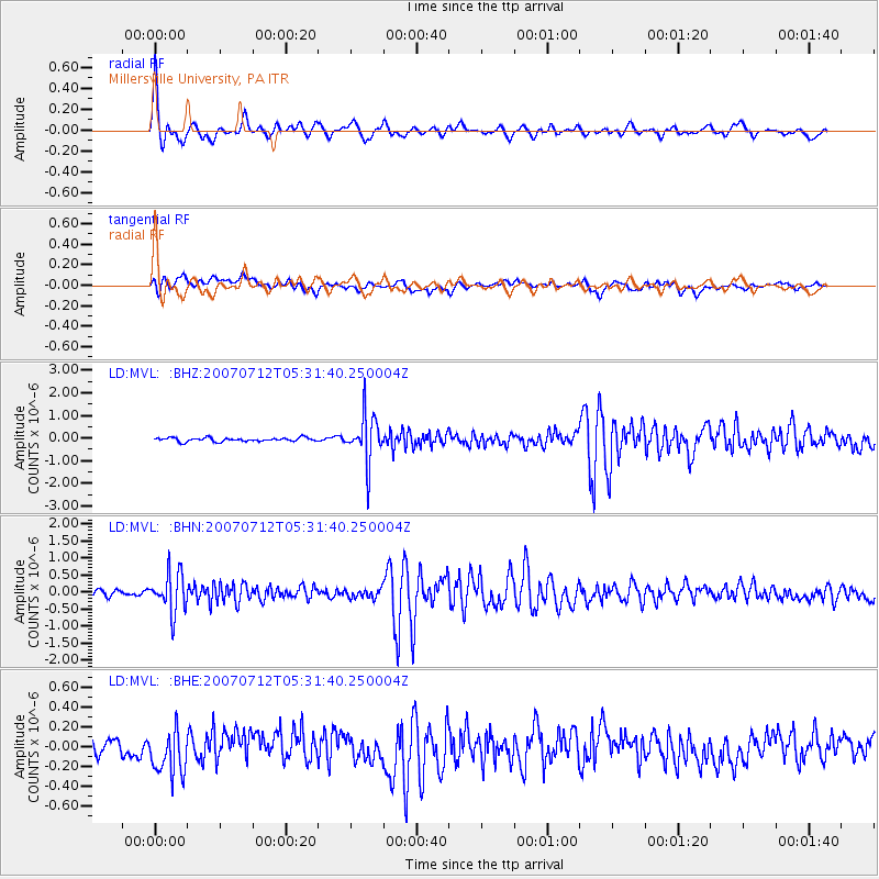
Signal To Noise
| Channel | StoN | STA | LTA |
| LD:MVL: :BHN:20070712T05:31:40.250004Z | 6.019136 | 5.764514E-7 | 9.576979E-8 |
| LD:MVL: :BHE:20070712T05:31:40.250004Z | 2.5188072 | 2.2932059E-7 | 9.104333E-8 |
| LD:MVL: :BHZ:20070712T05:31:40.250004Z | 12.189942 | 1.0283078E-6 | 8.435707E-8 |
| Arrivals |
| Ps | 5.9 SECOND |
| PpPs | 21 SECOND |
| PsPs/PpSs | 27 SECOND |


