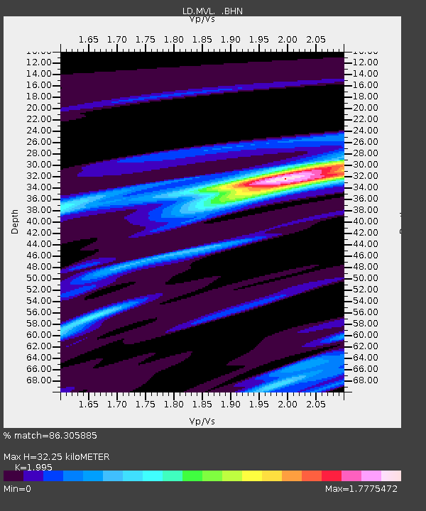
MVL Millersville University, PA - Earthquake Result Viewer
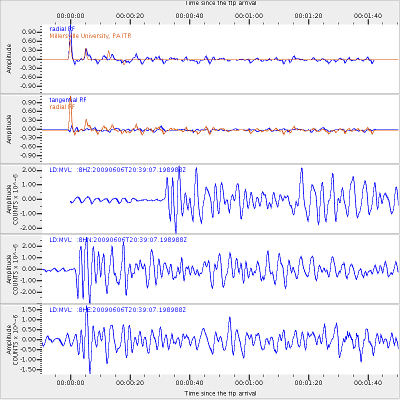
Earthquake location: Northern Mid-Atlantic Ridge
Earthquake latitude/longitude: 23.9/-46.1
Earthquake time(UTC): 2009/06/06 (157) 20:33:28 GMT
Earthquake Depth: 14 km
Earthquake Magnitude: 6.0 MB, 5.7 MS, 6.0 MW, 6.0 MW
Earthquake Catalog/Contributor: WHDF/NEIC
Network: LD Lamont-Doherty Cooperative Seismographic Network
Station: MVL Millersville University, PA
Lat/Lon: 40.00 N/76.35 W
Elevation: 91 m
Distance: 30.1 deg
Az: 309.519 deg
Baz: 113.166 deg
Ray Param: 0.07941454
Estimated Moho Depth: 32.25 km
Estimated Crust Vp/Vs: 2.00
Assumed Crust Vp: 6.419 km/s
Estimated Crust Vs: 3.218 km/s
Estimated Crust Poisson's Ratio: 0.33
Radial Match: 86.305885 %
Radial Bump: 314
Transverse Match: 62.76239 %
Transverse Bump: 400
SOD ConfigId: 2648
Insert Time: 2010-03-09 02:56:41.353 +0000
GWidth: 2.5
Max Bumps: 400
Tol: 0.001

Signal To Noise

ChannelStoNSTALTA
LD:MVL: :BHN:20090606T20:39:07.198988Z11.1993861.1846358E-61.05776856E-7
LD:MVL: :BHE:20090606T20:39:07.198988Z3.0408133.7653695E-71.2382773E-7
LD:MVL: :BHZ:20090606T20:39:07.198988Z6.59730637.442932E-71.1281774E-7
Arrivals
Ps5.4 SECOND
PpPs14 SECOND
PsPs/PpSs19 SECOND