You are here: Home > Network List > WY - Yellowstone Wyoming Seismic Network Stations List
> Station YFT Old Faithful, YNP, WY, USA > Earthquake Result Viewer
YFT Old Faithful, YNP, WY, USA - Earthquake Result Viewer

| Earthquake location: |
Bonin Islands, Japan Region |
| Earthquake latitude/longitude: |
27.8/139.8 |
| Earthquake time(UTC): |
2017/09/07 (250) 17:26:49 GMT |
| Earthquake Depth: |
448 km |
| Earthquake Magnitude: |
6.1 Mww |
| Earthquake Catalog/Contributor: |
NEIC PDE/us |
|
| Network: |
WY Yellowstone Wyoming Seismic Network |
| Station: |
YFT Old Faithful, YNP, WY, USA |
| Lat/Lon: |
44.45 N/110.84 W |
| Elevation: |
2292 m |
|
| Distance: |
83.5 deg |
| Az: |
42.85 deg |
| Baz: |
302.703 deg |
| Ray Param: |
0.04489858 |
| Estimated Moho Depth: |
11.5 km |
| Estimated Crust Vp/Vs: |
1.86 |
| Assumed Crust Vp: |
6.35 km/s |
| Estimated Crust Vs: |
3.423 km/s |
| Estimated Crust Poisson's Ratio: |
0.30 |
|
| Radial Match: |
90.33733 % |
| Radial Bump: |
400 |
| Transverse Match: |
71.31915 % |
| Transverse Bump: |
400 |
| SOD ConfigId: |
2307692 |
| Insert Time: |
2017-09-21 17:35:44.589 +0000 |
| GWidth: |
2.5 |
| Max Bumps: |
400 |
| Tol: |
0.001 |
|
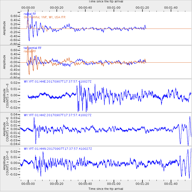
Signal To Noise
| Channel | StoN | STA | LTA |
| WY:YFT:01:HHZ:20170907T17:37:57.410027Z | 4.024521 | 8.130059E-9 | 2.020131E-9 |
| WY:YFT:01:HHN:20170907T17:37:57.410027Z | 1.0856087 | 3.4098553E-9 | 3.1409615E-9 |
| WY:YFT:01:HHE:20170907T17:37:57.410027Z | 2.5046797 | 5.9948113E-9 | 2.3934443E-9 |
| Arrivals |
| Ps | 1.6 SECOND |
| PpPs | 5.1 SECOND |
| PsPs/PpSs | 6.6 SECOND |


