You are here: Home > Network List > LD - Lamont-Doherty Cooperative Seismographic Network Stations List
> Station MVL Millersville University, PA > Earthquake Result Viewer
MVL Millersville University, PA - Earthquake Result Viewer

| Earthquake location: |
Northern Chile |
| Earthquake latitude/longitude: |
-19.4/-69.3 |
| Earthquake time(UTC): |
2001/07/24 (205) 05:00:09 GMT |
| Earthquake Depth: |
33 km |
| Earthquake Magnitude: |
5.7 MB, 6.2 MS, 6.3 MW, 6.3 MW |
| Earthquake Catalog/Contributor: |
WHDF/NEIC |
|
| Network: |
LD Lamont-Doherty Cooperative Seismographic Network |
| Station: |
MVL Millersville University, PA |
| Lat/Lon: |
40.00 N/76.35 W |
| Elevation: |
91 m |
|
| Distance: |
59.5 deg |
| Az: |
353.678 deg |
| Baz: |
172.226 deg |
| Ray Param: |
0.06208515 |
| Estimated Moho Depth: |
53.25 km |
| Estimated Crust Vp/Vs: |
2.10 |
| Assumed Crust Vp: |
6.419 km/s |
| Estimated Crust Vs: |
3.06 km/s |
| Estimated Crust Poisson's Ratio: |
0.35 |
|
| Radial Match: |
86.38518 % |
| Radial Bump: |
400 |
| Transverse Match: |
71.4311 % |
| Transverse Bump: |
400 |
| SOD ConfigId: |
20082 |
| Insert Time: |
2010-03-09 02:57:10.220 +0000 |
| GWidth: |
2.5 |
| Max Bumps: |
400 |
| Tol: |
0.001 |
|
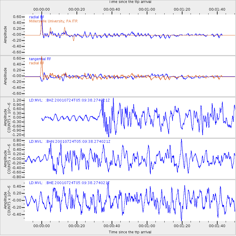
Signal To Noise
| Channel | StoN | STA | LTA |
| LD:MVL: :BHN:20010724T05:09:38.274021Z | 2.584808 | 1.7036231E-7 | 6.590907E-8 |
| LD:MVL: :BHE:20010724T05:09:38.274021Z | 1.7467933 | 1.4456278E-7 | 8.275895E-8 |
| LD:MVL: :BHZ:20010724T05:09:38.274021Z | 3.3402915 | 3.7316306E-7 | 1.1171572E-7 |
| Arrivals |
| Ps | 9.5 SECOND |
| PpPs | 25 SECOND |
| PsPs/PpSs | 34 SECOND |


