You are here: Home > Network List > LD - Lamont-Doherty Cooperative Seismographic Network Stations List
> Station MVL Millersville University, PA > Earthquake Result Viewer
MVL Millersville University, PA - Earthquake Result Viewer
| Earthquake location: |
Near Coast Of Peru |
| Earthquake latitude/longitude: |
-17.7/-71.6 |
| Earthquake time(UTC): |
2001/06/26 (177) 04:18:31 GMT |
| Earthquake Depth: |
24 km |
| Earthquake Magnitude: |
6.2 MB, 6.7 MS, 6.8 MW, 6.7 ME |
| Earthquake Catalog/Contributor: |
WHDF/NEIC |
|
| Network: |
LD Lamont-Doherty Cooperative Seismographic Network |
| Station: |
MVL Millersville University, PA |
| Lat/Lon: |
40.00 N/76.35 W |
| Elevation: |
91 m |
|
| Distance: |
57.6 deg |
| Az: |
355.724 deg |
| Baz: |
174.692 deg |
| Ray Param: |
0.06334753 |
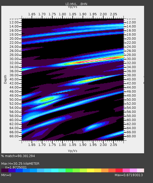
| Estimated Moho Depth: |
30.25 km |
| Estimated Crust Vp/Vs: |
1.97 |
| Assumed Crust Vp: |
6.419 km/s |
| Estimated Crust Vs: |
3.254 km/s |
| Estimated Crust Poisson's Ratio: |
0.33 |
|
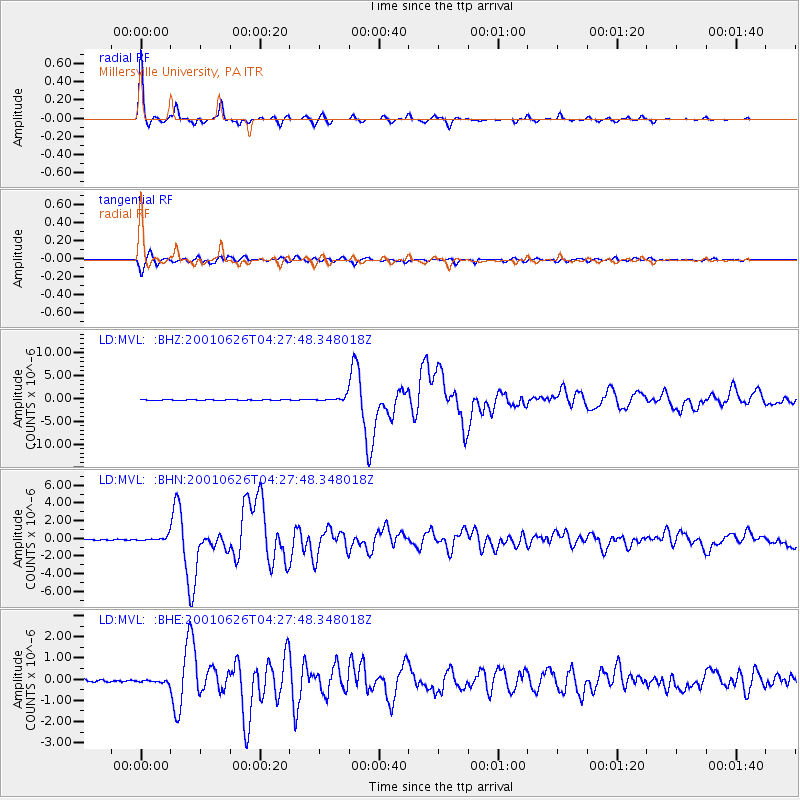
| Radial Match: |
98.381294 % |
| Radial Bump: |
218 |
| Transverse Match: |
95.52312 % |
| Transverse Bump: |
400 |
| SOD ConfigId: |
20082 |
| Insert Time: |
2010-03-09 02:57:11.943 +0000 |
| GWidth: |
2.5 |
| Max Bumps: |
400 |
| Tol: |
0.001 |
|
Signal To Noise
| Channel | StoN | STA | LTA |
| LD:MVL: :BHN:20010626T04:27:48.348018Z | 6.9592347 | 2.544111E-7 | 3.655734E-8 |
| LD:MVL: :BHE:20010626T04:27:48.348018Z | 1.13963 | 6.554547E-8 | 5.7514697E-8 |
| LD:MVL: :BHZ:20010626T04:27:48.348018Z | 6.588357 | 5.245258E-7 | 7.9614054E-8 |
| Arrivals |
| Ps | 4.8 SECOND |
| PpPs | 13 SECOND |
| PsPs/PpSs | 18 SECOND |


