You are here: Home > Network List > BK - Berkeley Digital Seismograph Network Stations List
> Station CMB Columbia College, Columbia, CA > Earthquake Result Viewer
CMB Columbia College, Columbia, CA - Earthquake Result Viewer
| Earthquake location: |
Near Coast Of Chiapas, Mexico |
| Earthquake latitude/longitude: |
15.1/-93.7 |
| Earthquake time(UTC): |
2017/09/08 (251) 04:49:21 GMT |
| Earthquake Depth: |
70 km |
| Earthquake Magnitude: |
8.1 Mww |
| Earthquake Catalog/Contributor: |
NEIC PDE/us |
|
| Network: |
BK Berkeley Digital Seismograph Network |
| Station: |
CMB Columbia College, Columbia, CA |
| Lat/Lon: |
38.03 N/120.39 W |
| Elevation: |
697 m |
|
| Distance: |
32.8 deg |
| Az: |
319.187 deg |
| Baz: |
126.908 deg |
| Ray Param: |
0.078305036 |
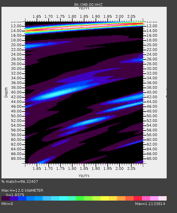
| Estimated Moho Depth: |
12.0 km |
| Estimated Crust Vp/Vs: |
1.84 |
| Assumed Crust Vp: |
6.597 km/s |
| Estimated Crust Vs: |
3.59 km/s |
| Estimated Crust Poisson's Ratio: |
0.29 |
|
| Radial Match: |
96.32407 % |
| Radial Bump: |
271 |
| Transverse Match: |
93.60858 % |
| Transverse Bump: |
400 |
| SOD ConfigId: |
2307692 |
| Insert Time: |
2017-09-22 04:49:43.269 +0000 |
| GWidth: |
2.5 |
| Max Bumps: |
400 |
| Tol: |
0.001 |
|

Signal To Noise
| Channel | StoN | STA | LTA |
| BK:CMB:00:HHZ:20170908T04:55:18.157986Z | 12.936739 | 5.05131E-6 | 3.904624E-7 |
| BK:CMB:00:HHN:20170908T04:55:18.157986Z | 6.71185 | 2.2801494E-6 | 3.3971995E-7 |
| BK:CMB:00:HHE:20170908T04:55:18.157986Z | 11.760102 | 1.9044198E-6 | 1.6193906E-7 |
| Arrivals |
| Ps | 1.7 SECOND |
| PpPs | 4.8 SECOND |
| PsPs/PpSs | 6.4 SECOND |


