You are here: Home > Network List > LD - Lamont-Doherty Cooperative Seismographic Network Stations List
> Station MVL Millersville University, PA > Earthquake Result Viewer
MVL Millersville University, PA - Earthquake Result Viewer
| Earthquake location: |
Costa Rica |
| Earthquake latitude/longitude: |
8.8/-84.0 |
| Earthquake time(UTC): |
2002/06/16 (167) 02:46:14 GMT |
| Earthquake Depth: |
35 km |
| Earthquake Magnitude: |
5.4 MB, 6.2 MS, 6.4 MW, 6.4 MW |
| Earthquake Catalog/Contributor: |
WHDF/NEIC |
|
| Network: |
LD Lamont-Doherty Cooperative Seismographic Network |
| Station: |
MVL Millersville University, PA |
| Lat/Lon: |
40.00 N/76.35 W |
| Elevation: |
91 m |
|
| Distance: |
31.8 deg |
| Az: |
11.169 deg |
| Baz: |
194.433 deg |
| Ray Param: |
0.07885844 |
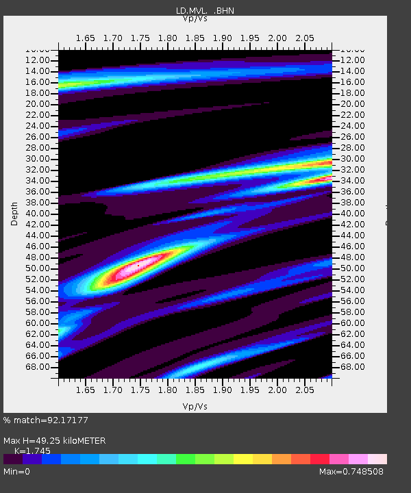
| Estimated Moho Depth: |
49.25 km |
| Estimated Crust Vp/Vs: |
1.75 |
| Assumed Crust Vp: |
6.419 km/s |
| Estimated Crust Vs: |
3.679 km/s |
| Estimated Crust Poisson's Ratio: |
0.26 |
|
| Radial Match: |
92.17177 % |
| Radial Bump: |
178 |
| Transverse Match: |
56.431473 % |
| Transverse Bump: |
400 |
| SOD ConfigId: |
20082 |
| Insert Time: |
2010-03-09 02:57:25.043 +0000 |
| GWidth: |
2.5 |
| Max Bumps: |
400 |
| Tol: |
0.001 |
|
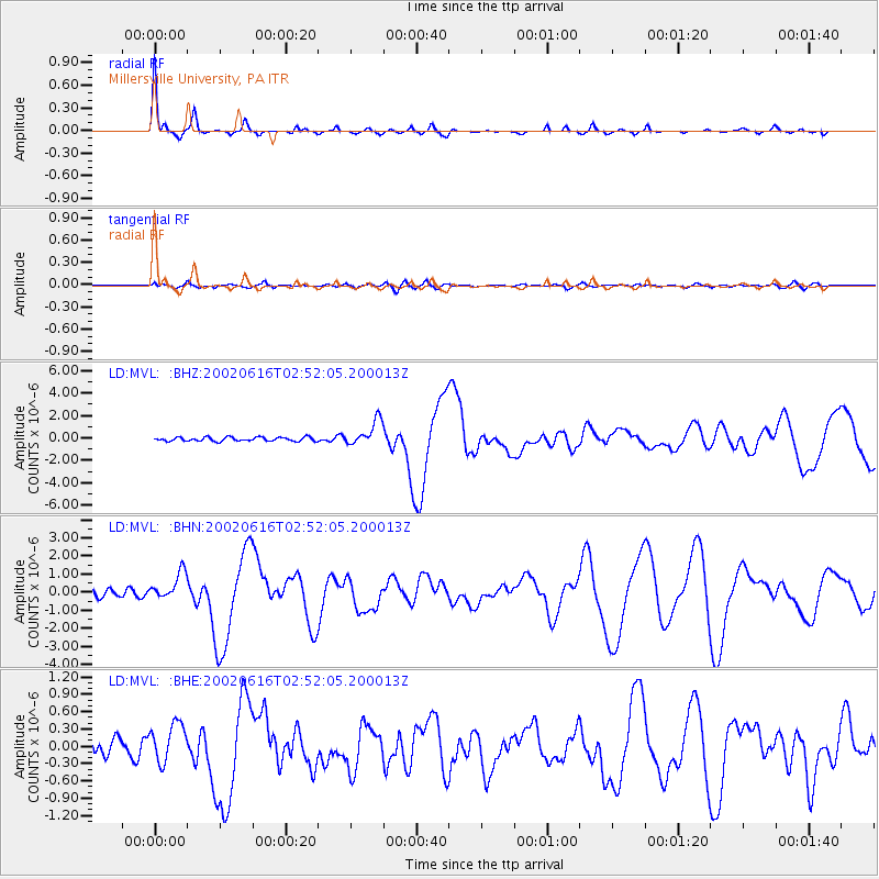
Signal To Noise
| Channel | StoN | STA | LTA |
| LD:MVL: :BHN:20020616T02:52:05.200013Z | 4.026687 | 7.4566327E-7 | 1.8518034E-7 |
| LD:MVL: :BHE:20020616T02:52:05.200013Z | 3.5323048 | 3.4056185E-7 | 9.64135E-8 |
| LD:MVL: :BHZ:20020616T02:52:05.200013Z | 6.218495 | 1.0953906E-6 | 1.7615044E-7 |
| Arrivals |
| Ps | 6.2 SECOND |
| PpPs | 19 SECOND |
| PsPs/PpSs | 26 SECOND |


