You are here: Home > Network List > CU - Caribbean Network (USGS) Stations List
> Station BBGH Gun Hill, Barbados > Earthquake Result Viewer
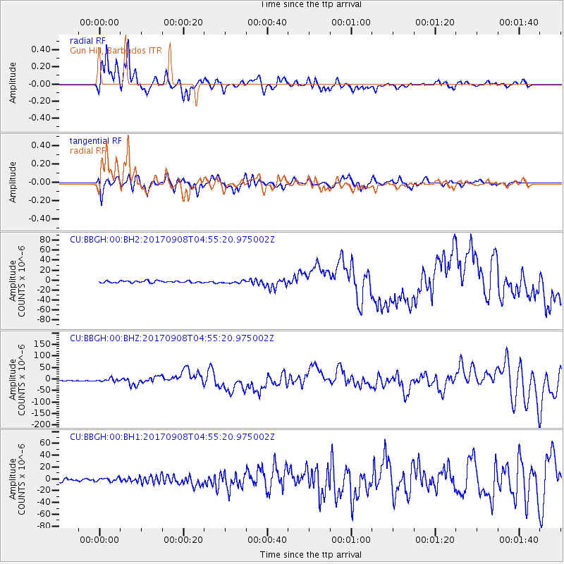
BBGH Gun Hill, Barbados - Earthquake Result Viewer
*The percent match for this event was below the threshold and hence no stack was calculated.
| Earthquake location: |
Near Coast Of Chiapas, Mexico |
| Earthquake latitude/longitude: |
15.1/-93.7 |
| Earthquake time(UTC): |
2017/09/08 (251) 04:49:21 GMT |
| Earthquake Depth: |
70 km |
| Earthquake Magnitude: |
8.1 Mww |
| Earthquake Catalog/Contributor: |
NEIC PDE/us |
|
| Network: |
CU Caribbean Network (USGS) |
| Station: |
BBGH Gun Hill, Barbados |
| Lat/Lon: |
13.14 N/59.56 W |
| Elevation: |
180 m |
|
| Distance: |
33.2 deg |
| Az: |
88.95 deg |
| Baz: |
277.461 deg |
| Ray Param: |
$rayparam |
*The percent match for this event was below the threshold and hence was not used in the summary stack. |
|
| Radial Match: |
84.193565 % |
| Radial Bump: |
388 |
| Transverse Match: |
52.28179 % |
| Transverse Bump: |
400 |
| SOD ConfigId: |
2307692 |
| Insert Time: |
2017-09-22 04:50:04.099 +0000 |
| GWidth: |
2.5 |
| Max Bumps: |
400 |
| Tol: |
0.001 |
|
Signal To Noise
| Channel | StoN | STA | LTA |
| CU:BBGH:00:BHZ:20170908T04:55:20.975002Z | 3.2192395 | 6.0932475E-6 | 1.8927599E-6 |
| CU:BBGH:00:BH1:20170908T04:55:20.975002Z | 1.6703312 | 2.9759915E-6 | 1.7816775E-6 |
| CU:BBGH:00:BH2:20170908T04:55:20.975002Z | 1.3388257 | 2.5329552E-6 | 1.8919231E-6 |
| Arrivals |
| Ps | |
| PpPs | |
| PsPs/PpSs | |


