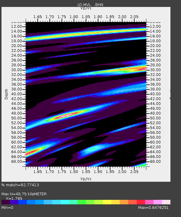
MVL Millersville University, PA - Earthquake Result Viewer

Earthquake location: Catamarca Province, Argentina
Earthquake latitude/longitude: -28.9/-66.8
Earthquake time(UTC): 2002/05/28 (148) 04:04:22 GMT
Earthquake Depth: 22 km
Earthquake Magnitude: 6.0 MB, 5.7 MS, 6.0 MW, 5.9 MW
Earthquake Catalog/Contributor: WHDF/NEIC
Network: LD Lamont-Doherty Cooperative Seismographic Network
Station: MVL Millersville University, PA
Lat/Lon: 40.00 N/76.35 W
Elevation: 91 m
Distance: 69.2 deg
Az: 352.159 deg
Baz: 171.045 deg
Ray Param: 0.05580763
Estimated Moho Depth: 48.75 km
Estimated Crust Vp/Vs: 1.76
Assumed Crust Vp: 6.419 km/s
Estimated Crust Vs: 3.637 km/s
Estimated Crust Poisson's Ratio: 0.26
Radial Match: 92.77413 %
Radial Bump: 400
Transverse Match: 78.78941 %
Transverse Bump: 400
SOD ConfigId: 20082
Insert Time: 2010-03-09 02:57:26.578 +0000
GWidth: 2.5
Max Bumps: 400
Tol: 0.001

Signal To Noise

ChannelStoNSTALTA
LD:MVL: :BHN:20020528T04:14:55.975007Z8.4870575.4276325E-76.395187E-8
LD:MVL: :BHE:20020528T04:14:55.975007Z1.08844718.6634486E-87.959458E-8
LD:MVL: :BHZ:20020528T04:14:55.975007Z11.8956191.1156276E-69.3784735E-8
Arrivals
Ps6.0 SECOND
PpPs20 SECOND
PsPs/PpSs26 SECOND