You are here: Home > Network List > G - GEOSCOPE Stations List
> Station FDF Fort de France, Martinique France > Earthquake Result Viewer
FDF Fort de France, Martinique France - Earthquake Result Viewer
| Earthquake location: |
Near Coast Of Chiapas, Mexico |
| Earthquake latitude/longitude: |
15.1/-93.7 |
| Earthquake time(UTC): |
2017/09/08 (251) 04:49:21 GMT |
| Earthquake Depth: |
70 km |
| Earthquake Magnitude: |
8.1 Mww |
| Earthquake Catalog/Contributor: |
NEIC PDE/us |
|
| Network: |
G GEOSCOPE |
| Station: |
FDF Fort de France, Martinique France |
| Lat/Lon: |
14.73 N/61.14 W |
| Elevation: |
467 m |
|
| Distance: |
31.5 deg |
| Az: |
86.316 deg |
| Baz: |
274.855 deg |
| Ray Param: |
0.07890046 |
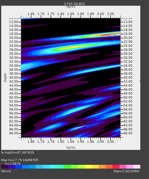
| Estimated Moho Depth: |
17.75 km |
| Estimated Crust Vp/Vs: |
2.10 |
| Assumed Crust Vp: |
5.88 km/s |
| Estimated Crust Vs: |
2.804 km/s |
| Estimated Crust Poisson's Ratio: |
0.35 |
|
| Radial Match: |
87.497635 % |
| Radial Bump: |
400 |
| Transverse Match: |
63.629456 % |
| Transverse Bump: |
400 |
| SOD ConfigId: |
2307692 |
| Insert Time: |
2017-09-22 04:50:14.392 +0000 |
| GWidth: |
2.5 |
| Max Bumps: |
400 |
| Tol: |
0.001 |
|
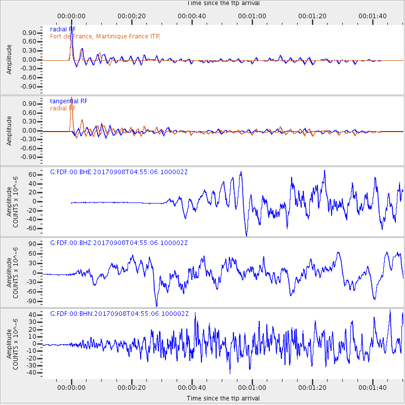
Signal To Noise
| Channel | StoN | STA | LTA |
| G:FDF:00:BHZ:20170908T04:55:06.100002Z | 5.280244 | 4.758467E-6 | 9.011833E-7 |
| G:FDF:00:BHN:20170908T04:55:06.100002Z | 4.3875713 | 2.0413995E-6 | 4.6526864E-7 |
| G:FDF:00:BHE:20170908T04:55:06.100002Z | 5.6844077 | 3.4648258E-6 | 6.095315E-7 |
| Arrivals |
| Ps | 3.5 SECOND |
| PpPs | 8.8 SECOND |
| PsPs/PpSs | 12 SECOND |


